Confirmed portrait of Francis Marion Moates (1837-1897) (left) with conjectured photo of Uncle Frank (right) from Moates family archive that is also thought to be his nephew James Marion Moates.
A Doorway Opens
In genealogical research, as in many other fields of inquiry, a seemingly insignificant footnote can be a door into a fascinating episode of a subject’s life. When I revisited the facts of my 2x great uncle Francis Marion Moates’ life, my eye feel again on the back of the headstone application for U.S. Veterans. (See below.) On the front (recto) it listed his service in the Florida Infantry CSA. In verso it read “29 Nov 65 Corp. Co. E 3rd Reg US VOL INF,” that is, Honorably Discharged 29 Nov 1865 as a corporal in Company E 3rd Regiment of United States (i.e. Union) Volunteer Infantry.
Verso (back side) of headstone application that mentions the union service of Corporal Francis M. Moates in 1864.
Rock Island Barracks, Illinois: A Union Prison “hell-hole”
I had read in the records of the imprisonment of Pvt. F.M. Moates in Nov 1863 following his capture at Chattanooga during the Battle of Missionary Ridge, an event that transpired very near my daughter’s present home in East Ridge, Tennessee. He was transferred to the infamous federal prison at Rock Island Barracks, Illinois. During my review of my notes, I looked more closely at what life was like at Rock Island. In a (hyphenated) word it was a “hell-hole.” Historians identify it as one of the largest and most notorious Union prison camps during the Civil War. [https://www.mycivilwar.com/pow/il-rock-island.html] The prison opened in December of 1863, a few weeks after the Battle of Missionary Ridge, Tennessee where Private Moates was captured. During its operation a “total of 12,192 Confederate prisoners were held at the prison camp. . . . A total of 1,964 prisoners died.” This is a causality rate of 16%, a fraction comparable to the death rate during the battle in Chattanooga itself in which he was captured. (8,000/48,900 CSA). [https://home.army.mil/ria/about/history]. Thus, imprisonment did not spell safety; on the contrary, it threatened continuing peril and hardship.
After a year of incarceration, Francis Marion Moates, who had been named for the revolutionary war hero “the old swamp fox” of South Carolina, “took the oath.” This was a serious, treasonous act. We, naturally, are prompted to imagine his motivation for this grave decision. He would have been regarded by his confederates as a despicable traitor to “the cause,” forever branded as “a White-washed rebel or a Galvanized Yankee.” Perhaps he was motivated by the opportunity to escape the potentially lethal conditions in prison. Alternatively, he could have been enticed by the offer of the $100 bounty for enlistment that he could forward to his family languishing back home in Northwest Florida. Furthermore, he probably had heard of the Union raid on his hometown of Eucheeanna (23 Sep 1864) where his wife and two children and his recently widowed mother suffered without provision following the raid. Winter likely would mean famine and starvation back home. Clearly, he must have inferred their desperate plight and perhaps saw enlistment as an expedient solution.
After he enlisted in the union army, he was—very probably—moved to a separate section of the prison as was standard procedure. This practice was for the protection of the inmate recruits against reprisal by their former comrades. Whatever Francis’ motivation records confirm his decisive action. Below is a photograph of his actual signature on his enlistment paper.
The signature of Francis Moates on his enlistment document.
He’s in the (Union) Army Now
By spring his newly mustered unit, Company E of the 3rd Regiment of the Unites States Volunteer Infantry (USVI), was transported to Ft Leavenworth, Kansas for training and marched by stages to Ft Riley and on to the Nebraska Territory. Dispatches report that the 3rd Regiment arrived on the frontier at Ft. Kearney, Nebraska on 9 April, 1864 after an arduous journey. (See annotated map.)
The stages of the deployment of Pvt. Moates’ unit after his release from prison.
On the Frontier at Ft Rankin/Sedgwick
Subsequently, Company E established its headquarters at Ft. Rankin, also known as Camp Rankin and later as Ft. Sedgwick, a few miles west of the township of Julesburg, Colorado Territory on the North Platte. His unit arrived about five months after an embarrassing and painful defeat of the troops garrisoned there. In a retaliation for the horrific massacre of Cheyenne and Arapaho men, women, and children at Sand Creek, allied tribes of Cherokee, Arapaho, and Lakota attacked the fort. By a cruel coincidence, the massacre occurred on the very day that Francis Moates enlisted over 700 miles east in Illinois. (29 Nov 1863) By at first feigning retreat, the native warriors lured the detachment of about 80 soldiers and 20 civilians out of the fortifications, then surrounded them. All but about 18 “Indian fighters” made it back to the relative shelter of the sod walls of the fort. Those that remained on the field of battle were dispatched by the warriors. The survivors stayed safe behind the earth works of the fort while the raiding party sacked the nearby town of Julesburg, pillaging for three days before burning it to the ground.
Francis and his comrades arrived at the fort about five weeks after the indigenous warriors had departed the immediate neighborhood. The new troopers were assigned to help complete the construction of Ft. Sedgwick and to provide armed guard for the mail coaches passing along the Platte. The march from Ft. Kearney, Nebraska to Julesburg, Colorado was an ordeal in itself. One commentator who made the trip within a few weeks of Pvt. Moates described it in a dispatch east thus: “After leaving Fort Kearney, we had an opportunity to witness for hundreds of miles the dreary monotony of the valley of the Platte. The river is now high and looks as if it might be navigable for steamers; but it is one of the most deceptive and treacherous of streams . . .” [Chicago Tribune, June 10, 1865 p 2]
Out of the Frying Pan into the Fire
The ominous presence of deadly war parties surely weighed on everyone’s mind and prompted an exhausting state of hyper vigilance. Reports of raids, killings, and scalping were flying everywhere. And privation was the order of the day. If life at Rock Island Barracks was miserable, existence on the plains of northeast Colorado was even more dismal. Ft. Rankin (later Ft Sedgwick) bore the sobriquet “Ft. Hell.” The reader can judge for himself the accuracy of this characterization from an examination of a photograph of the post where Corporal Moates was billeted. Despite the privation (or perhaps because of it) Private Moates had been promoted from the ranks on 1 Aug 1865.
Photograph of Ft Sedgwick/Ft Rankin in 1865.
A sense of the awful condition is provided for all time by Brevet General James F. Rusling, who performed an inspection in September 1866 and reported to congress, “The general character of post buildings was found to be bad, and is believed to be a fruitful source of discontent, desertions. One post inspected had lost 25 men by desertion in one month, with their cavalry horses, accoutrements, Spencer carbines, complete, and many instances of this kind were reported to me. In fact, no humane farmer east would think of sheltering his horses or cattle in such uncomfortable and wretched structures, huts, willow-hurdles, adobe shanties, as compose many of our posts in the new States and Territories now…’ Rusling, James F. (30 June 1867). “Affairs in Utah and the Territories”. House of Representatives 40th Cong. 2nd Session. Mis Doc. No. 153:18–19.
One may recall that Ft Sedgwick was the inspiration for the derelict and deserted fictional post that Lieutenant Dunbar occupied in the movie Dances with Wolves. While many aspects of the movie fort are fictional, the producers got right the general state of dereliction of this desolate outpost where the 26 year-old Floridian found himself. (Check the links below for a deleted scene from the film that explains how the fictional fort became to be deserted.)
Mustering Out at Ft Leavenworth, Kansas
But Great Uncle Francis endured the hardship. Apparently, his unit was spared any major conflict during his time on the prairie. Only limited skirmishes are reported in his area during his presence in the region. He, nevertheless, faced crude accommodation, brutal weather, boredom, and strict military discipline ever under the threat of hostile attack. At last, on 29 November 1865, his year-long enlistment complete and the hostilities of the civil war winding down, he and the rest of his regiment mustered out at Ft. Leavenworth, Kansas.
A vintage stereogram of Ft. Leavenworth, Kansas during the period of Francis Moates’ service.
Corp. Moates had drawn a pay $74.98 since his enlistment with a stoppage of $3.19 for damages to the property of Mr. John Mattis and others. There hangs a tale untold, we are sure. There are several individuals named John Mattis or Mattes who were immigrants from “Prussia,” that is, Germany, in Nebraska and environs that Francis may have interacted with. We can only speculate as to what were the events that left him responsible for property damage equivalent to three days wages or about $70 in present-day currency. Apparently, no dishonor accrued from the debt since Corporal Moates was mustered out with an honorable discharge.
Aftermath
The value of his and the service of his fellow “VOLS” is well summed up by Ronald Wirtz of the University of Nebraska.
“The 3rd U.S. Volunteer Infantry was only in service in Nebraska and points west less than nine months, and they left a frontier highway along the Platte that was still under serious and continuing threat from hostile Indians. Their contribution during that time on the frontier was not unimportant, however. They helped to stabilize a situation that could have become much more volatile by serving as a protective garrison force in strong points over a widely dispersed front. In company with a number of cavalry units, they built and maintained forts, posts, stage and telegraph stations, repaired telegraph lines, escorted emigrant trains, provided protection for private property, and helped to stock and manage warehouses and supply centers used by both civilians and the military. They were a stable and dependable force during a period characterized by unrest, insubordination, and even open mutiny among other military units in the region. It is fitting that they should be better remembered and honored for their service.” [“The 3rd U.S. Volunteer Infantry, Pt. 1: Galvanized Yankees Along the Platte,” Ronald Wirtz, University of Nebraska at Kearney https://openspaces.unk.edu/ctr-books/1/, accessed 28 Apr 2025]
Francis returned to his Eucheeanna home following his discharge, arriving by December, judging from the estimated date of conception of his third child, Emma. He came bearing his savings from his service that provided the resources he needed to pick up his life again. But he was a changed man, to be sure.
He appears in the 1867 voter registration list and the 1870 census for the county. We speculate that he resided in his boyhood home once more and began a steam saw mill and grist mill business in partnership with his brother James, who resided on the Dew property a mile down the road. But that is a story for another exploration in the full life of my great grandfather’s (James Marion Moates) uncle and name sake Francis Marion Moates. This story has enough drama and imaginative richness to evoke our sense of his character and experience.
He went to war a young man of barely 21 and returned five years later a much more mature veteran of two armies. He left a rebel and returned a Galvanized Yankee.
Links for future study:
Deleted scene of abandonment of Ft Sedgwick (fiction)
The historic Euchee Valley Presbyterian Church that has been active in one building or another since the 1840s. It was a familiar sight to the Dew and Moates families, lying as it does, across the present-day County Highway 183 S near its intersection with Count Highway 280 E, in Walton County south of De Funiak Springs, Florida.
Probably a Genealogist
“Probably a genealogist,” Mrs. Bailey remarked to her husband when they saw me photographing tombstones in the Euchee Valley Cemetery that Sunday afternoon in April 2024. They had come to visit the graves of his departed aunt and uncle when we greeted each other. I explained that I was looking for the final resting place of my ancestors, the Dews and the Moates family who had lived in the 1800s at the now vanished community of Eucheeanna, Walton County, Florida.
After a diligence search, I think that I at last have found the lost tombs. The difficulty arises, unfortunately, from the fact that only one legible grave stone remains today, that of my great-grand aunt Mary Ann Dew Sowell, listed on the cemetery catalog as plot #646. It seems, at first, to be a puzzle why she was buried here when much of her family lies in Dothan, Alabama, the city of residence of her and much of the Dew family after about 1890. The answer, I suspect, is the key to the identity of her companions in repose in the cemetery that lies outside of De Funiak Springs, Florida. The on-line numbering of the plots was helpful in finding the area of the relatively large cemetery. By “triangulating” from various surviving tombstones we were able to pinpoint the plots of interest. In fact, I doubt I would have found her grave without it. The area where Aunt Mary is (and much of the rest of her family probably are interred) appears below in the aerial photograph of the of the area graveyard lying within the white circle about fifty feet north of the service road and east of the row labelled “I. “
An aerial photograph of the Euchee Valley Cemetery and Presbyterian Church. The Dew-Moates area is located within the white circle near a crepe myrtle tree.
Mary Ann Dew Sowell, Rev. Dew’s Daughter
I found Mary Ann Dew Sowell’s grave after an arduous search. Entering through the service gate south of the white frame building of the Euchee Valley Presbyterian Church (see the aerial above and the photo below) I proceeded about half-way back toward the rear eastern side of the sacred grounds. Looking left, we can see a distinctive cross-shaped marker of the Irvine plot. This became a prominent landmark for finding the plots.
The location of the grave of Mary Ann Dew Sowell (left circle and arrow) relative to Irvine Family cross-shaped memorial (smaller circle on right). The image is looking eastward from the vantage point of the entrance of the service road into Euchee Valley Cemetery.
The cemetery is hard by the venerable Euchee Valley Presbyterian Church (featured image above) that was founded in 1827. Incidentally, Rev. Samuel D. Campbell of Virginia purchased a large tract of land across the road (currently County Highway 183 S) while he briefly served the church as pastor. After he had moved back to Virginia, his interest in the property on the frontier waned. Subsequently, in December 1859, he sold the 279 & 79/100 acre property to my 2x great grandfather, the Baptist Preacher Rev. Thomas Spenser Dew, Mary’s father for $450. A little over fifteen years later (17 April 1875) he would deed the tract to my 2x great uncle James W. Moates for the sum of $600, who farmed it until the later 1890s. Uncle James was the namesake of his nephew and my great grandfather, James Marion Moates. Apparently Uncle Jim had been living on the land, farming it, and working as a miller in collaboration with his brother Francis Marion Moates (for whom my mother’s grandfather was also named) since about 1870 when Rev. Dew had moved to Washington County to pastor the Union Baptist Church in Orange Hill. (See previous post).
Tombstone of Mary Ann Dew Sowell (Oct 29, 1951 – 26 May 1937) in Euchee Valley Cemetery. Image from Find-a-grave.com.
The Mystery of Neighboring Unmarked Graves
In the 1860 census Rev Dew appears with his four daughters and wife Elizabeth with a single unnamed enslaved man servant, aged 19, who had been with the family since at least 1850 when they lived in Ozark, Alabama. But by 1870 Rev. Dew was widowed and had moved to Washington County, forty miles east. He was accompanied by his youngest daughter Mary Ann, who found a husband in Ransom Sowell in the Orange Hill Community. Meanwhile, her sisters, the war widow Sarah Ann Dew McSween was living in Holmes County with her children and mother-in-law, and Ruth Ann Dew Moates (my great grandmother) who lived with her husband James Marion and mother-in-law Rachel Moates Miley Gleason on a farm adjacent to the Campbell-Dew-Moates property in a community later was known as “Campbelltown.” In subsequent decades Sarah Ann married Elder Malachi Murphy and moved to Altha, Calhoun County, Florida, while Ruth Ann moved to Orange Hill and subsequently to Dothan, Alabama where they lived out the remainder of their lives and where they are buried.
The relative orientation of the grave of Mary Ann Dew Sowell and the other hypothetically identified graves.
An examination of the layout of the plots adjacent to Mary’s resting place suggests the potential identity of the interred. Immediately to the north of Mary’s grave is an unidentified grave marked with nineteenth century era fired bricks. I suspect that this is the grave of Elizabeth Atkinson Dew, Mary’s mother. This idea is very plausible and persuasive. The next plot contains the unidentified grave of a child, marked with both similar bricks and a small granite, lichen-covered standing slab. I believe this is the final resting place of little Martha Ann Moates, the daughter of James and Ruth Ann Moates, who died on 24 March 1870 according to a family Bible entry. At about the same time (before Dec 1869) her Aunt Martha Ann Dew (and her namesake) disappeared from the public records, presumably dying before 1870. In the photograph below we see an overhead view of the three graves.
The hypothetical assignment of the identified graves adjacent to that of Mary Ann Dew Sowell.
The graves are clustered around a crepe myrtle tree, a traditional symbol of mourning and memorial. Other grave sites nestled in among the trunks of the flowering tree may be that of Martha Ann Moates’ other grandmother Rachel Moates Miley Gleason, who we infer died about 1872. Two other more speculative assignments are that of Noah Moates’ brother Jonathan Moates who died in the Confederate Army hospital in Georgia and whose corpse was claimed by his brother in 1863, and that of William Moates, Patriarch Noah’s son. who died shortly after the Moates family moved to the Euchee Valley in about 1849. The evidence for these conjectures is their proximity to each other, as well as the similarity in the marker: a simple granite slab. The extensive lichen overgrowth on the stones might be obscuring an engraving, although the growth may have eroded, over the century and a half, since its inscription. Clearly, these graves date from the 19th century—with the exception of Mary Ann’s final resting place. At the end of the century all of the surviving Moates-Dew family had relocated farther east in Florida and north into the wire grass region of Alabama where my mother’s people resided and she was reared.
The Moates Matriarch and Patriarch Elizabeth Harriet and Noah Moates
I had come to Walton County in hope of finding the graves of the patriarchs Noah and Elizabeth Harriet Pilcher Moates on the family farm a mile down the road. I found no evidence of a family graveyard on the White Creek Farm. I was pleased later to find the potential graves of their family as I have described. Then observing the graves that surrounded those that we have encountered above, I chanced upon two red sandstone markers. One was completely degrade but the one on the left (facing eastward) bore a partial inscription that froze me in mid-step. The sun was at just the right elevation to cause the surviving engraving to stand out in high contrast. I discerned the letters [ ] OAT H. Could this be the tombstone of Elizabeth Harriet Moat/Moates? I am persuaded that, indeed, this is the case. In the photograph I have superimposed my probably reconstruction of the inscription on the image of the stone. The “O” with its idiosyncratic central dot is unmistakable. The date of death appears to be Aug 1870 (a date unquestionably ending in zero). This correlates well with Dame Moates appearance (as “Elizabeth Wilhout age 73” as we explored in an earlier blog) in the 1870 census taken the 25th Day of August that year. On her right—the traditional position of the male spouse—is a much degraded sandstone monument that I infer marks the grave of Noah Moates, my 3x great grandfather, who perished on 2 Feb 1864 according to unconfirmed genealogical information that I found on ancestry.com.
Highly deteriorated red sandstone marker that appears to read [M]oat H, Aug 1870 that we identify as the headstone of Elizabeth Harriet Moates.
Deteriorated red sandstone monument assigned to Noah Moates father of Rachel Moates “Miley” Gleason, James W. Moates, and Francis Marion Moates, grandfather of James Marion Moates, the 2x grandfather of the author.
Gone But Not Forgotten
Thus, I came away from the cemetery that day with a partial sense of satisfaction that I had located—with as much certainty as is common in such matters—the final resting place of several of my forebears. We may ask, “What difference does it make?” In reply, I declare that their final resting place helps us remember them and recall their story. And as the frequent epitaph declares they are “Gone but not forgotten.”
Indeed, we will remember them and say their names. I once heard Mandy Patinkin, distinguished actor, remark during an interview with Dr. Henry Louis Gates, Jr. that while he was performing the musical Carousel Oscar Hammerstein encouraged him saying “As long as there is one person on earth who remembers you, it is not over.” I see it as my job as a genealogist and historian to remember and help you remember. It is therefore “Not Over.”
In 1869—not long after his beloved wife of over 30 years, Elizabeth Atkinson Dew had died—Rev. Thomas Spenser Dew left his farm and ministry in Eucheeanna in Walton County, Florida that was situated across the road from the Euchee Valley Presbyterian Church to move to the community of Orange Hill, Washington County, formerly known as “Hickory Hill.”
The migration of Rev. Thomas S. Dew and daughter Mary Ann Dew from Eucheeanna to Orange Hill (formerly known as Hickory Hill) Florida in about 1869, traced on an 1857 vintage map.
In the US Census of Aug 1870, James W. Moates (mis-transcribed as James “Wilhout”) resided with wife Flora, widowed mother Elizabeth, and son Daniel Noah, on the Dew-Campbell property that Rev Dew ultimately sold to him in 1875. In the months before his relocation, grief descended upon the Dew household: Martha Ann, one of his four daughters, also died and was laid to rest near her mother in Euchee Valley Cemetery. In just a few months, Martha Ann Moates, his granddaughter (the child of my great grandparents James Marion Moates and Ruth Ann Dew Moates) joined them. Daughter Mary Ann Dew, at age 20 in 1870, kept house for the Reverend, while daughter Ruth Ann Dew Moates with husband James Marion and Mother-in-law Rachel Moates Gleason remained in Eucheeanna on a holding adjacent to the Dew-Campbell farm. Meanwhile, daughter Sarah Ann Dew McSween—widow of Robert McSween who was killed in action in Mississippi—lived in Holmes County with her two girls and Mother-in-law.
Photograph from County Highway 280 E looking into the 19th century holding of Rev. Thomas Dew (owner 1860-1875) and James W. Moates (owner 1875-1884).
Section 23 and adjacent aliquots of land passed into the possession of several Moates Family members. In fact, family history recounts how the gentle rise in the landscape the buggy driver encountered as he approached the cemetery from the town center to the west was informally called “Moates’ Hill.” Below is a schematic of the property patents in the early post-war days.
Schematic map of many known holdings in the Euchee Valley in 1870. Pastor Dew purchased about 240 acres in 1860 from Rev. Samuel Campbell, who pastored the Presbyterian Church nearby for about a year before returning to his native Virginia.
Thus, in 1869 Pastor Dew moved 30 miles farther east, less than a decade after he had come from Ozark, Alabama to the Euchee Valley with his wife, four daughters and an enslaved man servant to assist the church planter Rev. Lester R. Sims in evangelizing and serving the sinners and saints of western Florida in the Euchee Valley. The congregation he came east to lead in Washington County was called “Union Baptist Church.” Such a designation suggests that the church shared space with another church, such as the Methodists. This arrangement was common on the frontier. He appears in the minutes of the West Florida Baptist Association for that year as its pastor, while we can infer from a note that the congregation of the Orange Hill Baptist Church had dissolved. (See image) Subsequently, in later WFBA minutes Rev. Dew appears as pastor of the (reconstituted) Orange Hill Baptist Church.
The minutes of the 1869 meeting of the West Florida Baptist Association (WFBC) which lists Thomas S. Dew as pastor of the Union Baptist Church. Image Source: Florida Memories; https://floridabaptisthistory.org/association-minutes-2/
Both in the oral history of the Orange Hill Baptist Church documented by WPA historians in 1936 and in the church history of the Orange Hill United Methodist Church (OHUMC) we find that the first church house was a log structure located south of the Orange Hill Academy. The Academy was held in high esteem as the first Baptist-supported educational institution founded in Florida. The Baptist congregation met in the Academy building but later moved into the log structure shared by the two congregations, the Baptists and the Methodists—at least until it burned to the ground. Following the conflagration, the Baptists relocated farther south off the hill while the Methodists rebuilt the church on the same spot. The reconstructed (Methodist) church house is shown in the photo. (The photo was obtained from the archives of OHUMC.) Ultimately, the Methodist congregation built a modern church house on the site of the defunct Academy. (See photo.)
Church house built by Orange Hill Methodist Church on the site of the original log church shared with Union/ Orange Hill Baptist Church after the original structure burned. Note the substantial stone steps leading to the front door of the church house. Image Source: OHMC archives. United Methodist Church 1167 Sunday Road, Chipley, FL, 32428. The cemetery is visible to the right of the church house. (Photo taken by S. Matteson 14 April 2024)
On 14 April 2024, I visited the site of Orange Hill United Methodist Church on Sunday Road, south of Chipley, Florida. Based on information gleaned from early aerial photographs of the summit of Orange Hill, I drove to the Orange Hill Cemetery on Sunday Rd and began my archaeological survey. I explored the fields across the road from the cemetery and came upon a relic of the old church house. In aerial photographs from the mid-twentieth century the original church house site is clearly visible. I stumbled upon the chiseled stone steps that led to the sanctuary.
Aerial Photograph captured 1966. Source: Historical Aerial Photos NETRONLINE https://www.historicaerials.comThe surviving stone steps to the sanctuary built by congregation of the Orange Hill Methodist Church that replaced the original log structure. Source: Sam Matteson 14 April 2024.
While I was examining the remnant of the meeting house I glanced down to find a solitary charred piece of wood lying on the surface of the space that lay under the razed and removed clapboard church. Could this be a relic from the original log cabin? It is a definite possibility. I stepped to a place a few yards opposite the entrance and recalled my Great-great grandfather Rev Thomas Spencer Dew, who may have stood in that spot about 150 years before (1869-74) and proclaimed the gospel to the good people of Orange Hill.
A charred piece of wood found at the putative location of the original shared meeting house of the Orange Hill Methodist Church and the Union/Orange Hill (reconstituted) Baptist Church in the 1870s. Source: Sam Matteson 14 April 2024.
Moates-Dew Family oral history reports that the Reverend was a prophetic and powerful preacher who proclaimed the gospel until the year he died at age 89. As I clutched that charred wood in my hand, I felt a renewed connection to and appreciation of my long-departed ancestor on that Sunday afternoon that transcended dry DNA data and genealogical analysis.
Rev. Thomas Spencer Dew (age about 86) holding his large Bible in about 1894 in Dothan, Alabama.
In this present age we are a rootless generation. On average, Americans change residence 11.7 times in their lives. [Source: https://www.steinwaymovers.com/industry-insights/ ] This statistic seems very plausible to me, since in my own childhood my parents relocated six times before I left home, and subsequently, I lived as a nomad myself—moving to sixteen “permanent” residences after founding my own nuclear family—a fact of which I have been reminded by my children, who themselves have itchy feet, as well. So it is not remarkable that I share with many of my contemporaries an inchoate longing for an old home place, a Heimat, lost. Recently, I came across a word for this emotion—hiraeth. This word is a unique gift of the Welsh culture, but is a universal experience, I believe. And having a word for a nebulous sensation somehow seems to give us a handle to grapple with it. I am persuaded that from time to time everybody experiences morriño (Galacian Spanish dialect for a longing for a homeland), or if we were Portuguese we might call it suadade, or even anemoia, the longing for an unknown home or that special homesickness for one’s ancestral home the Germans call Heimatweh.
Where to look for a home?
Whatever word we attach to this feeling, my genealogical research has raised the hope of uncovering my patrimonial estate or a homeplace (a Heimat?) that could be the nexus of my hiraeth. But along which branch of the family should I search? I was closest in distance and in affection to my maternal grandparents, Noah Theodore Webster Moates (1889-1972) and Katie Roberta “Bertie” Holland Moates (1888-1966). I learned in studying them that my grandfather was named for his great grandfather Noah Moates (1793-1864). My Pa died never knowing his grandmother’s father. Noah the Elder appears in the records of Montgomery County, Alabama in 1826 as a Justice of the Peace, barely six years after it became a state. His honor was enumerated in the 1830 Census for Montgomery County, Alabama, as well. In the next two decades his name resurfaces in the company of kinsmen who also emigrated from 96 District of South Carolina and were of French Huguenot stock. Noah (1793) as I often identify him, was the grandson of Jonathan Silas Motes, we believe. These family members of unestablished relation who also pioneered Alabama include Carey Motes or Moates, William (or William C) Motes, Elizabeth, Elihu, John, and John T. Motes, Moats, or Moates (a father-son pair we suspect.) Other relatives flooded into south central Alabama at about the same time, notably the brothers Morris and Dendy Motes. The name appears in various forms, as the orthography was unsettled in the 18th and 19th centuries. Historians suggest that the original form was Delamotte or a variant thereof. Nevertheless, in 1833 a clerk entered the purchase of a parcel of land that also appears in a Land Patent that is clearly Noah (1793). We can know precisely where the property was located because of the PLSS, the Public Land Survey System established in the US initially by the Land Ordinance of 1785. [Source: https://en.wikipedia.org/wiki/Land_Ordinance_ooudaef_1785 ] The key features of this system are the descriptors township, range, and section. Each township is—usually—a square, six miles by six miles in extent with each square mile comprising a section of land. Thus the sections each consist of approximately 640 acres. The PLSS was the brainchild of Thomas Jefferson, who proposed the “Rectangular Land System” that was enacted into law as the Land Ordinance of 1785. [Source: https://mlrs.blm.gov/s/article/PLSS-Information ], barely eight years before Noah (1793) was born.
A Note on Locating Public Lands
In the PLSS, key baselines were defined at various latitudes. In south Alabama the principal baseline aligns with the border with Florida. Thus, the southern edge of township 13N lies 78 (13×6) miles north of the Florida-Alabama line. Likewise, meridians running north–south were also defined, such as the one passing through St. Stephens, Alabama from which ranges were numbered east and west in six mile increments. Thus, range 20E lies 120 miles east of the St. Stephens meridian. Below is a map (courtesy of Wikipedia) of the lands subject to the PLSS.
Map of PLSS (Public Land Survey System) regions with baselines and medians. Source: Wikipedia.comDetail from previous map showing Alabama-Florida baseline and St. Stephens Meridian.
The public land was offered for sale by the Federal government (after having dispossessed the indigenous peoples who had collectively stewarded it for millennia). The 6×6 mile townships (containing 36 square miles) were subdivided into 36 sections of approximately 1 square mile (or 640 acres), each numbered in a consistent serpentine or boustrophedon (as the ox plows) pattern. Beginning in the northeast corner the sections are numbered consecutively first westward then eastward, alternating directions as shown in the illustration below. Section 6 is highlighted for special consideration.
Layout of sections in a township that is identified by township number and range number. On the right section 6 that is highlighted in the township map. Quarter SW (Southwest) of section 6, is outlined in black. The eastern half of the quarter section SW is highlighted in blue.
Such holdings were frequently too large an investment for the small farmer, so the sections were subsequently further subdivided into quarters, designated NE (northeast), NW (northwest), SE (southeast) and SW (southwest), each comprising 160 acres. Further subdivision was designed by halving (80 acres) or quartering (40 acres) the quarter section as E½ SW¼ (or ESW) as illustrated in the enlargement. Thus, ESW 13N 20E 6, means eastern half of section 6, township 13 north and range 20 east containing 80 acres. These PLSS designations can be correlated to modern property lines using various on-line resources.
Eighty Acres of “Virgin” Alabama Land
The choice of our example was not arbitrary. Indeed, in the land book from the 19th century we can see the land transactions that included Noah Moates. Notice the entry 3/4 down the page.
The page in original the land book for section 6 Township 13 [north] Range 20 [east] showing the transaction in which Noah Moates purchases the Eastern half of the Southwest quarter.
A close examination of the image reveals that in 1819, at the dawn of the statehood of Alabama one Carey Motes of Abbeville, South Carolina purchased the SW quarter of section 6 Township 13 [N] and Range 20 [E]. Subsequently, Noah Moates purchased the aliquot (a partial section) E½SW¼ of that quarter on 16 September 1831. The price was $1.25 per acre. Thus, he paid $105.40, a sizeable sum in 1831. The land was patented in 1838. A patent functioned as an official deed of ownership.
A later copy confirms that Noah not only purchased the land, but it also reveals his neighbors to the east were his kinsmen William Chesley and John T. Moates (aka Motes or Moats) with neighbors to the north and west to be Messrs. Armstrong Mitchell, Swann, and Massingill.
Land book summary page listing Noah Moates and his neighbors.
We believe that William C. Moates was Noah’s brother while John T. was his uncle, or cousin. Together the South Carolina immigrants formed an enclave, by the late 1830s, having bought up a patchwork of land parcels.
A schematic of the ownership of the aliquots (parcels) surrounding the Moates enclave that was formed by the patchwork of half- and quarter-quarter sections owned by the Moates “boys.”
Below is a twentieth century topographic map of section 6, with the aliquots for Noah (1793) and his brother William Chesley Moates indicated.
A 1971 topographic map with the property lines indicated. The map indicates roads and houses that correspond to those seen in the aerial photographs.Corresponding aerial photograph in which we can observe the collection of buildings, circled in red.
Above is an overlay of the Noah Moates (1831) aliquot and the William C. Motes (1827) aliquot on a 1977 aerial photograph. We can discern houses (circled) and cabins that are made more visible in enlargement (below).
A enlargement of the area where the structures appear on the Little Sandy Creek farm,
The Little Sandy Creek Farm (E ½ SW ¼ Section 6 Township 13 N Range 20 E)
Close examination places the GPS coordinates of the big house at 32.13193, -86.09279. There appears to be a well a few yards west of the Big House.
We can confirm that it is likely that Noah Moates (1793) resided on this land, dubbed the “Little Sandy Creek Farm,” before the census of 1830. He probably leased or rented the property from his relative Carey Motes in the 1820s. He was residing here in 1830 when the census was made. This we can infer by noting the order and subsequently location of the individuals in the census list. If we plot the location of all of the neighbors who appear in the census in order we see that the census taker meandered from farmhouse to farmhouse. Apparently, the enumerator missed the Noah Moates family on his first pass finding Chesley and John T at home but revisited the Little Sandy Creek Farm successfully a second time. Yellow designates the estimated trek before visiting the Noah Moates family (white circle) and the red arrows the path of the enumerator in successive visits to other farmsteads.
The approximate path taken by the enumerator of the Montgomery County in visiting the farmsteads of the families listed in the 1830 Census.
Noah Moates does not appear by name in any known census before 1830 and in 1840 appears in the census for Pike County while his son James W. Moates appears in Montgomery County, adjacent to his Uncle William C. Moates’ property. By 1850 Noah and family had moved to Eucheeanna, Florida, appearing in the census there. We can conclude that, most likely, Noah Moates owned and/or resided on the Little Sandy Creek farm from before 1823 when daughter Rachel was born in Alabama to about 1849 when they moved south. Thus, this is the first documented “homeplace” of the Noah Moates clan, although they occupied the site for only about 20 to 25 years before moving on. Therefore, is this not the “Ole Homeplace” of our family?
The Ole Homeplace Today
But what became of the Ole Homeplace and what remains of the place today? We can trace the history of the ownership of this tract of land down through the nearly two centuries by searching the property tax books and reading the newspapers for real estate sales. Sometime after 1850 the Little Sandy Creek (LSC) farm was sold to Mr. Martin Willis (1825-1866). We infer this fact from Elizabeth Moates’ (William’s wife’s) appearance as its manager in the 1850 agricultural census in a listing adjacent to William C. In 1866 Mr. Willis died. The property was inventoried in his probate records that also decree that, since the estate was insolvent, much of the real estate holdings were to be sold except for the tract reserved for his widow’s residence that corresponds exactly to the LSC farm. Sarah Ann Ingram Willis (1829-1895), widow and Martin’s heir held the property until her death in 1895. Her son Asa “Acie” James Willis (1860-1946) inherited the estate and sold it in 1899 to Thomas Jefferson Gray (1864-1937). T. J., farmed the property with his nephew William Chappell Gray (1901-1978) until Uncle Tom died. He bequeathed the farm to his nephew, since he had no surviving children. Chappell’s stepdaughter intimated in a private communication that T. J.’s siblings and other relations were upset by this bequest. Nevertheless, Chappell proved his mettle by his hard work for several years to pay off the outstanding debts on the property. Chappell Gray was a colorful character in his own right. He overcame a scandal from a scrape with the law as an alleged bootlegger to become a respected politician and prominent cotton farmer. At his death in 1978 title to the land passed to his second wife Frances Elizabeth Cason Bishop Gray (1912-1996), who subsequently sold the property in 1986 to Mr. H. R. (Robert) Dudley of Dudley Bros. Lumber, the entity that currently owns the acreage and manages it as timberland through a holding company.
I contacted a member of Mr. Dudley’s family who is a principal in the lumber company and obtained permission to “walk the property.” On Sunday 21 May 2023, my wife and I drove to the logging road entrance off Athey Road, Montgomery County, Alabama and I began my trek back into the past.
A Walk in the Woods
I had for weeks planned my excursion into the woods that surrounded the location of the Little Sandy Creek property. I had mapped our drive in our all-wheel drive Subaru along the logging road that peeked through the trees in the Google satellite views of the area. I carefully overlayed the 1971 aerial images with the corresponding Google images. My plan was to drive to the second clearing, where a white structure appeared to be, and then trek the 150 yards northward to the site of the antique buildings shown in the fifty-year-old aerials. Carolyn, my wife and partner would remain in the vehicle nearby.
A merged image of a Google satellite view and the 1971 aerial photograph.
We found the entrance to the property with only minor difficulty, but—how shall I put it?—nothing else went according to plan.
The first obstacle we faced was a locked gate.
Locked gate.
If I had obtained access by borrowing a key, travel by automobile, even a four wheel drive like our Subaru Outback, would have been impossible. In at least three places, fallen timber blocked the track. Moreover, recent rains had filled the many unnamed tributaries of the Little Sandy Creek that traversed the road to produce potential impassable mud holes.
The tract blocked by fallen timber (left). An unnamed tributary in flood posted further obstacles.
Along the way I started a doe. I realized one of the reasons for the locked gate. It was deterrence of unauthorized deer poaching. As further evidence, on the return trek I picked up a buck antler soughed off in a previous season.
I surprised a doe in a meadow. A young bucks antler from a previous season lay at the edge of a clearing. I wondered if some of the deer’s ancestors provided sustenance for my ancestors. I silently thanked the deer for making it possible for my family to thrive in the wilderness.
So leaving my partner in the car at the locked gate your intrepid trekker (me) set off on foot to reach the site that his diligent study of the on-line maps indicated lay nearly a half mile into the woods. I had rehearsed the path in my imagination many times and felt initially confident that I could easily (and rapidly) navigate to the spot using my GPS-enabled Google Map. I did not count on the disorienting nature of the deep, unfamiliar woods or the change in the landscape since the last aerial photograph. Still I could draw on my dead-reckoning skills acquired as a youth traipsing barefoot about the swamps of my coastal Alabama childhood home. All began well as I followed the logging road, as I had envisioned from my armchair weeks earlier. I made it without incident to the first clearing, probably the site of the William Chesley Motes’ home two hundred years earlier. Nothing remained there except the grass-covered meadow. It was there that I took what turned out to be a wrong turn. I was led astray by an official-looking sign bearing a number 1 and an arrow. The sky was overcast so I could not readily discern the direction by shadows. The old bush wisdom of moss-on-tree-trunks-indicating-north was of no use since moss grew in abundance on all sides of the oak trees. Furthermore, my phone did not have a compass app installed.
Moss grew on all sides of the tree trunks. I lost my sense of direction for a time.
I had promised Carolyn that I would check in frequently using our walkie-talkies that we had purchased for the occasion. It worked once when we tested it but I could not reach her subsequently, either because of technical difficulties or operator error. Minutes passed as I stumbled through the forest heading south (instead of west). At last, I reached what the number 1 alluded to: a plowed field. The field still appeared as a landmark on my satellite map. I realized that I had wandered farther afield in the wrong direction so I turned northward to hike and intercept the logging trail again. At that moment I recalled the sad stories my research had brought to light of the people who became victims of this very swamp. In September 1974 eighty-year-old Leatha Wilson was found dead not far from where I stood. Newspaper accounts of the event also alluded to the disappearance of five-year-old Willie Williams, who in 1969 ran into the swamp with his dog. His dog returned. He did not. He was never found. I suppressed the panic that began to arise that the victims must have felt. I focused on the map and the little blue dot that represented my position and verified that I was now moving toward my goal. I also heard the sound of traffic on the Troy Highway to my right. I also tried to keep an eye out for snakes and other dangers. But I overlooked, concealed in the under growth, a fallen log that caught my toe. I fell face first into the leaf litter. As I lay on the soft ground, just then my phone chimed a notification of an incoming text. Carolyn was worried. I replied with a cramped hand as I lay in the dirt, “Will tAlk soob” [sic]. Awkward is too kind of a description of my state.
My meanderings led me to a tilled field. Not my intended destination.The swamp had claimed two victims in 1969 and 1974. I wondered briefly if it would take another in 2023.
Rising from my humbled position, I consulted the map. (See left below) It suggested that I return to the highway and drive to a different place and walk in again. I chose to bushwhack through the woods to the logging trail and thence on to my destination. I realized that the dark patches in the satellite were fens, natural swampy ponds that were persistent landmarks. Thus skirting the muck, I managed to return to the logging trail and ultimately to the second clearing that I had determined lay just south of the homeplace I had seen in the 1971 aerial photograph. When I arrived at the clearing, the little white building I was expecting was gone. Only four concrete footings remained of what I had surmised was a storage shed. I was filled with renewed hope, however at the “ground truth” that my goal was within reach. I identified the path I had seen on the satellite view and proceeded up the path about 300 feet counting out the paces, left-foot-right-foot, 5 feet, left-foot-right-foot, 10 feet. Then I turned right and trekked about 100 feet into the woods. Surveying the understory, I caught sight of debris. Twentieth-century trash lay scattered about. Derelict appliances were strewn among the oaks and pines: a top loading washing machine, a bronze-colored refrigerator, a toppled gas range. Surveying wider I encountered the remains of a well that survived the demolition of the houses. It was a large diameter concrete culvert set vertically in the ground. I glimpsed the surface of muddy water about three feet below the surrounding forest floor. The GPS coordinates corresponded to those that I had concluded were those locating the well, as shown in the aerial photograph. This was indeed the place I had identified.
I had the benefit of a navigation app on my phone. I knew were I was but initially did not know which direction to go. This contributed in part to my unintended side trip.
I brought out my trusty metal detector in hope of finding buried evidence of antique nails, a way to date a structure. In a few seconds of sweeping the area it sounded an encouraging “beep, beep!” I dug eagerly with growing anticipation. What came to light a few inches beneath the surface is shown in the photo below (left). The object that I uncovered was a tricycle wheel with a rubber tire through which a large tree root had insinuated itself. The find discouraged further metal detecting. My calculation was that there would be too many “modern” objects that would mask any earlier objects. A thorough scan would consume all the time I had remaining in fruitless searching. Nevertheless, I wanted to document what I had found as best I could. I retrieved my soil corer and extracted a sample (right). It revealed a black topsoil layer of about 4 inches (10 cm) deep overlying an abrupt transition to sand. This finding suggested that since the homeplace was abandoned in the late twentieth century, the composted leaf litter has built up at about 5 mm per year or more. In 200 years any artifact might be buried as deep as a meter (40 inches). I was not prepared for an archeological dig. From the soil core I concluded that before the demolition of the house in the late twentieth century the soil was probably barren packed sand. Later, as I reflected, I realized that the find, a child’s toy, was evidence that the house that had stood on this spot had been home to a family, perhaps a tenant, in the era when the property was owned by Chappell Gray. Perhaps the child, who rode what is now a relic of at least a half century vintage, was known to Leatha Wilson and might have been a playmate of Willie Williams, as well.
I, at last, found the site of the house shown in the 1971 image.My metal detector find, a child’s trike wheel. (left) I used corer to sample the subsurface soil stratigraphy. It revealed a four inch layer of loam overlying packed sand.
A low mound caught my eye. I moved closer and observed that it was a pile of rubble. “The remains of the chimney,” I thought. Indeed, the pile was substantial: about three foot high and eight to ten foot in diameter. I extracted representative samples from the debris pile. I thought to myself, “These will be helpful in establishing when this house was built.”
Rubble pile of chimney bricks. Insert: specimen selected for dating and analysis.
Later I documented the bricks with detailed photographs that I shared with various experts in the field of brick making and masonry. Below is a montage of a representative half brick. Close examination reveals ten V-grooves running the length of the brick as well as telltale longitudinal scratches, except at the ends where I noticed vertical striations that suggested the clay had been end cut.
The Tale of a Brick
Representative brick collected from ruins at site of Little Sandy Creek homeplace. Expert opinion (Don Adkins of Old South Brick) suggests this is a stiff-mud extruded end cut brick. The process was introduced in the US in late 1870s and became common in Alabama after 1895 or later. These bricks perhaps were manufactured by Jenkins Brick of Wetumpka, Alabama.
Later that same day, when we visited the Pioneer Museum of Alabama in Troy, we observed similar bricks appearing in a reconstructed tenant house on the grounds of the museum. We ultimately ascertained that the original structure(s) stood on the Segars Plantation in Troy. Hugh Richmond Segars was granted a patent for the farm in 1851. Thus, we concluded that the bricks, if indeed they came from the Segars Place, must date from after the mid-1850s.
Reconstructed tenant house from Segars Plantation, Troy, Alabama located currently at the Pioneer Museum of Alabama, uses brick that are very similar to those I recovered from the homeplace site. Hugh Richmond Segars (1822-1884) patented land in 1851 for his plantation from whence the original structure(s) were salvaged. In 1860 he had 10 enslaved servants housed in two houses on the estate. The museum exhibit was reconstructed from the ruins of these two houses. Therefore, the bricks probably date after the founding of the farm in about 1850. Note that the bricks markedly resemble those found on the Little Sandy Creek Farm.
As I was composing this post, I had an illuminating discussion with Mr. Don Adkins of Old South Brick and Supply, Jackson, Mississippi, a vendor of vintage and antique brick. From the photographs and description that I had sent him he was able to determine that the bricks were fabricated by the stiff-mud-extrusion-end-cut process that was employed by Jenkins Brick Company of Wetumpka and later Montgomery, Alabama, beginning in the late 1890s. He opined that the bricks could not be any older than 1895 because the extrusion process was only patented in 1863 and took decades to gain currency. In 1899 the Jenkins Brick Company that used the method of brick making was incorporated in Wetumpka, Alabama, north of Montgomery. Bricks from earlier periods would have been hand molded and probably would not have survived the damp of the swamp, since they were low-temperature fired and lacked much vitrification. He further remarked that the age of the bricks did not negate the possibility that the house had been built earlier, since it was common practice to tear down failing chimneys and rebuild them with newer brick. Thus, all we can say is that very little remains of the original homeplace except for the land. The cleared space where the late 19th century structures stood is in the process of returning to its pre-habitation condition. Studying the photograph of the site below, we see smaller diameter hardwoods estimated to be less than 50 years in maturity. The 1820-vintage buildings of the Noah Moates family have vanished, victims of the ravages of Nature and of subsequent “improvements” by succeeding occupants of the land.
A view of the previously clear area that is or is near the site of the original Alabama ancestral homeplace of the Noah Moates family that we call the Little Sandy Creek Farm. Nothing apparently remains of the 1820-1850 homestead except the land.
My children expressed their concern that I would be disappointed by what I found in my search to satisfy my hiraeth. I assured them that I did not know what to expect, so anything would be acceptable. What I found was a sense of the presence of my ancestors. The land originally was verdant and provided them with timber to build a log home, probably like examples of the two-room “Dog Trot” style common in central Alabama at the time. It was here that my great-great grandmother Rachel Moates, the mother of James Marion Moates (aka Miley), was born in 1823.
I concluded, also, that the land never really belongs to us. Not the earth, not the water, not the sky above. At best we borrow it from Nature. Indeed we belong to the land, the place of our nativity. It gets in at the root and works itself out in us and our children up the trunk of our family tree and out to the branches and needles or leaves as it does with the loblolly pine and water oaks.
Succeeding generations of men will—in the name of progress—obliterate every trace of our habitation. Likewise, Nature will reclaim her proprietorship if we do not continually maintain and restore the place. I am reminded of the dialog of the film Out of Africa in which Karen Blixen complains to Denys Hatton, her lover:
Karen: “Every time I turn my back it wants to go wild again.”
Denys: “It will go wild.”
In truth, the locale of my Alabama homeplace, my Heimat, has gone wild. All that remains is the earth upon which they walked. Thus, I can think of no more appropriate talisman of my family’s presence in this space than a souvenir sample of the soil they trod centuries before. With the help of my grandson Elijah Matteson, age six, 5x great grandson of Noah Moates, I prepared 2 dram (about 7 cc) labelled samples of soil that I had collected at the site, accompanied by a certificate of provenance and authenticity. Below is a photograph of one such sample with the certificate. They lie upon an antique depression-era table, factory built over a century ago, and refinished for my mother Audrey Moates Matteson (1926-1998) by my grandfather Noah Theodore Webster Moates (1889-1972) over a half a century ago during my memorable summer with my beloved grands. It is the people that make a place live in our memory. It is this longing for knowing them and touching them where our hiraeth becomes palpable. In knowing the place where our roots lie, we know ourselves a little better. Being there was worth the effort to get there.
The Gulf of Mexico as viewed from Ft. Walton Beach, Florida in May 2023. The beauty and calm of the sea belie its danger and hunger for souls.
Every once in a while, when researching family genealogy and personal history, I come across an incident that is so compelling that it breaks my heart. When this happens the history of my ancestors and of their struggles coalesce in my consciousness and their story demands telling. Such is the case in the family of Francis Marion and Mary Peel Moates, my great grandfather’s uncle and aunt. The tragedy they experienced centered on the sinking of the Sloop Amelia.
The Family of Francis Marion Moates and Mary Rebecca Peel
I first met Francis in my inquiries when he appeared as a young man, the uncle of my great grandfather James Marion Moates; since he was only six years older than Francis M. he was more like an elder brother than uncle. For him James Marion Moates was named, in part. Uncle Frank (as I shall call him) was born in land-locked Pike County, Alabama probably near Briar Hill and probably in the very house where Grandpa Jim first opened his eyes six years later.) Frank and Jim served together in the same unit of the Florida Infantry (CSA) during the Civil War. At Chattanooga, however, their paths separated: Frank was captured at the Battle of Missionary Ridge, while Jim was injured but eluded the Blue Coats.
Frank had married Mary Rebecca Peel in Euchee Anna, Florida in 1859 before enlisting. Together they had ten children by 1886 when Mary ended her child bearing years at age 44.
The F. M/ Moates family made their home in northwest Florida, first near present day DeFuniak Springs where Noah Moates had settled in 1850, then near other family in Orange Hill, Washington County just down the road from Jim and his growing family. But ultimately—as we learn from Mary’s obituary (Panama City Pilot 15 Nov 1928 p 6)—in February 1879 the couple and their seven children, who had been born by then, moved to the shores of St. Andrews Bay near present day Panama City, Florida. They purchased a half section and built what is reported to be the first sawmill in the county following the war. Below is a montage of present day West Bay with its million-dollar lots and an 1888 map showing the Moates Mill in Section 35 Township 3S Range 15W. The red highlighted lot on the left marks the approximate location of the mill today where no trace of the historic structure remains, erased by progress.
Location of Moates’ sawmill on shore of St. Andrews Bay, Florida in 1890 (right) and 2023 (left)
It is no wonder that after a decade of living beside the Gulf, two of the Moates girls married mariners. The eldest daughter Mary Francis Moates (born 1863 in Eucheeanna) married William Stephens, a commercial fisherman, while Elizabeth Carrie Moates (born in 1874, five years before the move to St. Andrews) married a Greek immigrant, John Constantine. Captain John piloted a freighting sloop, the Amelia back and forth across the Gulf of Mexico visiting ports from New Orleans to Tampa.
A Fateful Excursion
So it was that one Sunday, 29 March 1897, a party of nine souls embarked from St. Andrews Bay bound for Pensacola, about hundred and thirty nautical miles away. On board where Captain John Constantine, his wife Carrie Moates Constantine, their three young children (sons Nicky age 3, Tony C age 6 months, and an as-yet-unidentified child), Mary Moates Stephens and her daughter “Nettie” about sixteen, the Moates sisters’ brother Ben Moates (25), and a young Greek man variously identified as “Moses” or “Christopher Samiota” (probably actually Samiotes). The newspaper reports are a bit sketchy about the relationship of the young Greek to the party: some dismiss him as only a deck hand, others allude to him as Miss Stephens’ fiancé. In any case, the passengers were intent on visiting relatives in Pensacola and obtaining a trousseau for Nettie’s upcoming wedding according to newspaper accounts. Captain Constantine had more commercial interests in mind, however, as he had on-loaded a large number of casks of oysters for delivery to the dock in Pensacola. The merchant sailing vessel sat low in the water, burdened with the heavy load below deck.
A Typical Merchant Sloop
No drawing or detailed description of the sloop survives except for the title and the capacity of “six to seven tons.” As an aid to our creative imagination we provide the images below of such sloops that often were single masted but occasionally sported twin masts and ranged from 30 to 40 foot in length with sails fore and aft. Several prior mentions of a Sloop Amelia appear in the shipping news. One interesting account tells of a lightning strike in New Orleans that did extensive damage a few years earlier. Perhaps the more superstitious might have taken such an event as an evil omen, but on this occasion the happy group were oblivious to such dark clouds of superstition as well as the real storm brewing over the horizon of the Gulf waters.
The 19th century sloop Welcome (left), a model of a typical sloop that plied the waters of the Gulf (center), and a twentieth century reconstruction of a sloop (right).
The Tragedy
Ben Moates was found, washed up on shore in Pensacola, half dead. He had clung to a hatch to stay afloat through the raging gale. He told, as he recovered, of hours of the captain and crew fighting the storm and struggling to keep the ship afloat only, at last, to be capsized and flooded when the hatches were ripped from the holds. He had tried to save a woman (presumably his sister) and her child, but failed when they were torn from his grasp and drifted away to their death. In all, eight souls perished, claimed by the implacable fury. He, like a real-life Ishmael, alone survived to tell the tale. I have wondered if Ben spoke much of his harrowing misadventure in the remaining 56 years of his life. He left no known children to tell us, since his only child with wife Nora Thompson Moates died at birth. I suspect that he may have been troubled with survivor’s guilt, but we cannot know. Nevertheless, the event did not put him off venturing out to sea again apparently for he continued his career as a fisherman.
Benjamin Franklin Moates (1872-1953), sole survivor of the Sloop Amelia
The Aftermath
Grief like the waves on the white beaches of northwest Florida came in pulses in the weeks following the tragedy. Bodies were discovered from time to time for the next several weeks on the beaches from Pensacola to Dauphin Island near Mobile where I was born 50 years later. The first found were the corpses of two of the Constantine boys Nicky and Tony, one on each shore of the entrance to the harbor at Pensacola along with the stern board bearing the ship name Amelia. In the coming weeks, Mr. William Stevens diligently searched for his wife and daughter. He responded to each announcement of a body encountered, often with great disappointment. Ultimately, he apparently did recover the remains of his drowned wife Mary Francis and daughter Lettie. The only other body, greatly decomposed, to come ashore was identified by jewelry to be those of Carrie Moates Constantine. The other three individuals were never see again: Captain John Constantine, Christopher Samiotes, and the unidentified child of Carrie and John Constantine.
Map of coast of Gulf of Mexico coast from St. Andrews/Panama City (right) and Pensacola (left) The figures indicate the approximate location where bodies were found, washed ashore. The X indicates the approximate spot of the accident.
The bodies that the sea gave back were interred in St Andrews and their names were engraved in stone on their headstones. They faded from memory anyway as those who knew and loved them passed, themselves. First to succumb was Francis Marion Moates, who was already an invalid in 1895 (possibly as a result of his imprisonment during the Civil War), Alternatively, he may have been overcome by the tragedy of losing two of his beloved daughters and four of his grandchildren in a single blow. He died about six months after the accident, as noted in his death notice in the local paper.
His death left Mary a widow, at age 55, caring still for three minor children at home. Mary Peel Moates had already been through much in her life. As a new mother of two in 1864 she endured the raid on her hometown of Eucheeanna when Union General Ashtoth’s troops occupied and stripped the countryside of food and horses, liberating the enslaved people and leaving her destitute. And she endured with apparent equanimity the latest blow to her family just two days before the 38th anniversary of her marriage to Francis Marion. Not content to play the victim, Mary applied for a widow’s pension on 7 Nov 1897 very soon (if not days before) Francis’ death. With the help of her grown sons she provided for the family, Three years later, in the 1900 Census she is enumerated as “Head” with her sons, including Ben, listed as “fishermen.” Twenty-three years later we find grandmother Mary Moates residing with the family of her youngest daughter Annie Moates Porter. In 1928, Mary Rebecca Peel Moates died in St. Andrews, Florida, surrounded by family at the ripe age of 86.
The Take Away
As I contemplated this tragedy I was reminded of Psalm 107.
And the words of Job seem apropos as well to the stoic character that Mary seemed to exhibit.
Yet, I am astonished at the way the knowledge of the great tragedy has affected me 126 years after the fact. I was particularly struck by their loss as I gazed out on the Gulf of Mexico while vacationing with my wife and son’s family in Ft. Walton Beach, Florida, on Okaloosa Island halfway between St. Andrews and Pensacola. Perhaps the lesson we should take away from this story is this: life is precious and brief. We sail upon its surface with no guarantees of success. I here renew my resolve not to take a clear day and a fair wind as my right or as a given but, rather, as a gift, a grace. May we not squander our time here in meaninglessness and pettiness, and thus the memory of those who were lost that March Sunday will continue to be a blessing to us today.
In 1793 Noah Moates, I believe, was born to William Chesley Moates Sr. (1760-1830) and Rachel Adams Moates (1763-1830), descendants of Huguenot immigrants from France who were residing in the 96 District (after 1800 Abbeville County) of upcountry South Carolina. Responding to the urges of “Alabama Fever,” Noah at about the age of 27, along with his young bride Elizabeth Pilcher Moates (1796-1874) and infant son William (1815-1849), began his westward journey on the Fall Line Road across Georgia to the Federal Road to Macon and Columbus, Georgia and on to Montgomery County, Alabama. The first direct evidence of Noah’s presence in Alabama appears as a record of his appointment as Justice of the Peace for Montgomery County in 1825. Indirect evidence comes from the later census-documented 1823 birth year of daughter Rachel (1823-1872) that is universally reported to have occurred in Alabama. She was the mother of my mother’s grandfather, James Marion Moates (1843-1921) by an illicit affair with William Goodman Miley of Pike County, Alabama.
Noah settled on and later patented a half-quarter section near Little Sandy Creek in Montgomery County, Alabama on 16 Sept 1831. The legal description of this aliquot is East Half Southwest Quarter Section 6 Township 13 North Range 20 East. (Abbreviated E½ SW¼ 13 N 20 E 6). The land had previously been purchased and held in 1819 by a Carey Motes of Abbeville, S.C. (Carey may have been a kinsman of Noah, but the relationship is unclear) Nevertheless, apparently Noah Moates rented and resided on the land until he purchased it. The ownership of the tract subsequently (after about 1853) transferred from Noah Moates to Martin Willis (1825-1866), and—on his death—to his heirs: wife Sarah Ann Ingram Willis (1829-1895) and son Asa “Acie” James Willis (1860-1946). The latter held the property until he sold it in 1899 to Thomas Jefferson Gray (1864-1937), upon whose death the tract passed to William Chappell Gray (1901-1978). The bequest by T. J. Gray, who had no living children, to his nephew Chappell angered Chappell’s relations according to W. C. Gray’s step daughter but the diligence of the younger Mr. Gray in paying off the debt on the property assuaged any doubt of his intent and resolve. Indeed, Chappel held the property to the end of his days. Chappell Gray was a colorful character in his own right, one who overcame legal troubles for bootlegging in the 1920s to become a long-time county commissioner and widely respected and successful cotton planter. Following his death, the estate of W. Chappell Gray sold the property to H. R. (Robert) Dudley of Dudley Bros. Lumber in 1987, the current owners. Interestingly, a farmhouse survived on the property at least until 1971 as shown in the aerial photograph below. It was located at 32.13193° N, 86.09279° W.
Reproduction of Montgomery County Land Book. Note that Noah Moates appears among the owners of section 6 in the lower part of the page.Aerial photograph (1971) of Chappell Gray property (owned 1831-1853 by Noah Moates) showing structures and well, now demolished and covered in forest. The big house was located at 32.13193° N, 86.09279° W.
The Little Sandy Creek Farm, Montgomery County, Alabama
On 21 May 2023, I, the author Samuel Matteson (with permission of the owners), visited the site of the former structures. Evidence of the demolished buildings remained. I believe that near this spot all of the children of Noah Moates were born [except for William and the possible exception of Francis Marion Moates (1837-1897)]. This assertion includes, notably, Rachel Moates (1823-1874), mother of James Marion Moates and great-great grandmother of the author. A rubble pile of chimney bricks and a debris field is all that remain. Twentieth-century trash such as abandoned kitchen appliances are sad evidence of the buildings that once graced the farm.
Photographs made by the author on his visit to the site on 21 May 2023 that document the current conditions of the farmstead. All that remains of the buildings that appear in the 1971 aerial are household debris and rubble, as attested by this pile of chimney bricks. shown in the lower image
A Move to Briar Hill, Pike County, Alabama
In 1836 hostilities broke out between a bellicose faction of the Creek Indian Nation and Euro-American colonizers. This threat may have been in the mind of Noah Moates, in about 1835, when he moved from his farm in Montgomery County (the Little Sandy Creek Farm) to occupy a leased acreage about 15 miles farther south in Pike County.
While it is hard to know for sure Noah’s motivations, the locus of the conflict later called the “Second Indian War” was indeed near the Alabama-Georgia border east of Montgomery city, not far away. We can establish that about that time Noah moved to an as-yet-unidentified location near Briar Hill (Township 11N Range 19E). It was probably here that Francis Marion Moates was born in 1837 and where, six years later, James Marion Moates (named in part for his toddler uncle) first saw the Alabama sunlight on 3 Nov 1843. As we asserted earlier, James Marion “Miley” Moates was the offspring of an illicit affair between his mother Rachel Moates (1823-1874) and a married man, Deacon William Goodman Miley, co-founder of the Pisgah Primitive Baptist Church just a few miles from the farm on which the Moates family likely resided from about 1835 to about 1849. (Elsewhere in earlier posts in this blog under the general title “Tell Me Thy Name” I have detailed how we have come to this conclusion. The interested reader is refered to that discussion. Our purpose here is a chronicle of Father Noah Moates.) In the aftermath of the presumed scandal surrounding James’ birth, both the Moates family and the Miley family decamped from the community. The Mileys headed to Tampa, Hillsborough County, Florida. At about the same time In 1850 Noah Moates and family appear in the census for Eucheeanna, Walton County, Florida. Meanwhile, Rachel and James were living under the name “Miley” nearby in Walton County. Interestingly, an 1849 advertisement claimed “Valuable Land” offered in Eucheeanna with generous terms: quarter down and one quarter annually for the remaining three years. Thus, if Noah Moates bid on the property in December 1849 and made the down payment in early 1850 for a tract in Eucheeanna, he would have finished payment in 1853, as he is recorded doing. The patent was awarded four years later for several acres near the confluence of Folks Creek and White Creek about one mile west of the Euchee Valley Presbyterian Church. The advertisement shown may be the one Noah Moates actually saw and to which he responded.
A New Home in the Euchee Valley on the Banks of White Creek
The legal description of the likely boyhood home of James Marion Moates in Eucheeanna, Walton County, Florida is Northwest ¼ of Southwest ¼ Section 6 Township 13 North Range 20 East (NWSW 13N 20E 6). The “ole swimmin’ hole,” as the current owner referenced the confluence of Folks Creek and White Creek, is located on the property and is shown in the photograph. The location is familiar to the current owner Mr. James Armstrong (age 84), who swam there as a youth and also was probably a very familiar sight to James Marion a century and a half earlier. The property remained home to the Moates family for decades, even after Noah expired near the end of the Civil War. Those in residence at the farmhouse on 24 Sep 1864 saw a Union detachment invade the town and “requisition” all livestock and provisions in the area. The winter months that followed must have been lean times for them, indeed. Moreover, I conjecture that the mortal remains of several family members are buried somewhere on the property in unmarked graves, albeit a fact that is as yet unconfirmed. In happier times it was here in February 1866 that my great grandfather James Marion Moates married Ruth Ann Dew, daughter of the Preacher Thomas Spenser Dew.
Thus, a life—that began in South Carolina—ended in the community of Eucheeanna, Walton County, Florida. Along the way he and Elizabeth sired a family of three daughters and three sons: Rachel Moates, Martha Jane Moates Teal Lassiter, Sarah Elizabeth Moates Hutto, William Moates, James W. Moates, and Francis Marion Moates.
What Motivated Noah’s Odyssey?
The question naturally arises: “What motivated the odyssey of Noah Moates?” “Alabama Fever” was rampant in the Carolinas in the 1820s. Apparently, it was particularly epidemic in the Moates family, since several of Noah’s family members moved to the region at the same time, notably his immediate neighbors William Chesley Moates Jr. (brother) and John T. Moates (uncle or cousin), and Morris Motes (cousin) and Morris’ brothers. Noah’s brother Jonathan Moates also accompanied his elder brother on the journey and interacted frequently over the decades, sometimes even as a member of Noah’s household.
“Land!” was the source of the infection, indeed. Verdant, virgin, affordable soil was to be had in the areas recently offered by the government that it had wrenched from the control of the newly dispossessed indigenous inhabitants. But after about fifteen years of cultivation in the manner of the early 19th century agriculture the sandy soil of Noah’s Montgomery County farm probably became exhausted and crop yields declined. It would be nearly a century before scientific methods of agriculture would be pioneered by—ironically a black man, Booker T. Washington—and show the way to sustainable yields. Moreover, the years of 1830-40 saw heavy rains and poor crops in Alabama. The Little Sandy Creek property is still prone to flooding and is often described as a “swamp.” In fact, in the 20th century at least two individuals perished after becoming mired in the trackless swamp of the Little Sandy Creek woods. Thus, while he still retained ownership of the Montgomery County property (son James Moates is listed as head of household in Montgomery County in 1840), Noah also leased a farm near Briar Hill, as documented in the 1840 Census for Pike County. It was here that Rachel Moates, his eldest unwed daughter, was “found with child.” Five-to-six years after James Marion Miley Moates was born, Noah moved his family to the thriving community of Eucheeanna in Walton County, Florida. Perhaps a little bastard “Miley” running about the community was too great a shame to endure. In any case, sometime soon after 1850 Noah Moates sold the Montgomery County property to Martin Willis and reinvested the proceeds in over 200 acres in the Euchee Valley. In Florida the family grew and endured, spreading in the following decades throughout northwest Florida and southeast Alabama. Noah died sometime about 1864, followed a few years later by his widow Elizabeth after 1870, who had lived in the Argyle home of their son James W. Moates in her final days.
After Mr. Miley died, although she was under no legal obligation to remain unwed during his lifetime, Rachel Moates “Miley” married a Mr. Gleason of Eucheeanna. He was probably the elderly, blind father of Phillip Gleason who appears in the 1860 Census. In the 1870 census we find Rachel Gleason residing with her son James and his wife Ruth Ann Dew Moates in Eucheeanna, soon after their first infant Mary Ann Moates had died. In the succeeding years she vanishes from the historical record, presumably laid to rest on the family farm of her father..
The Meaning of Land to a Southerner
Land was always the attraction and the goal of our pioneer ancestors. It meant status as well as survival. Indeed, the earth was ever the source of their sustenance as farmers and was inevitably the ultimate destination of their bodies as mortals.
Photographs of ancestors can put us in more intimate touch with them. We are often challenged, however, to identify the individuals in the image.
I and my siblings have inherited from our mother a tantalizing photograph of her Moates Family from about 1911, according to my reckoning.
On the obverse of the print my mother Audrey Moates Matteson (1936-1998) identified, to the best of her knowledge, the individuals present in the photo. Below is the image. On the back she wrote:
As an aid to singling out efficiently the individuals I have added a number tag to each.
The individuals with whom she would be most familiar 50-plus years later would be her Father “Papa” Noah Theodore Webster Moates (back row labelled #4 ), her Grandmother “Mammy” Ruth Ann Dew Moates (seated row labelled #2 ), her Grandfather “Daddy” James Marion Moates (seated row labelled #6), and her “Mother” Katie Robertia “Bertie” Holland Moates (seated row labelled #7 ). In addition, she identifies from photos she must have seen over the years of her elder siblings Ruth Dew Moates (“Sister” later Mrs. Howell Kirkland) (child labelled #5) on her grandmother’s lap and Noah Bernard Moates on his mother’s lap (labelled #8).
Mother may have attempted to identify the other individuals by inference since she may not have immediately recognized them because they appear as they were about 14 years before her birth. I believe that she was correct in identifying “Aunt Docie,” i.e. Theodocia Ernestine Temple Moates (labelled seated #1) and several of her children, but erred in the detail attribution of some of the other individuals.
In our approach we first establish the probably date that the photograph as taken and use that information to test conjectures about the potential identities. If our hypothetical designations are correct, then each individual must correspond in age to their age on the date of the image, for example. Lap babies #5 and #8 help date the photo. Mother Audrey identified her siblings respectively as Ruth Dew Moates (born June 1908 and known to me as “Aunt Sister”) and Noah B. Moates (born Jul 1909). They appear to be at least 24 months and 12 months. Therefore, the date must be later than the summer of 1910. At left is an image from another archive (the Moates-Kirkland archive curated by Dorothy George Taylor, grand daughter of Miley Moates). The individuals are identified as James Marion Moates with infants Noah B (left) and Ruth Dew Moates (right). The inserts are extracts from the photograph above for comparison. Each is wearing the same clothing. Thus, the image was made the same day and as the same people.
A careful examination of the background also reveals that the image was made outside of a house in the side yard. We can discern clapboards on the left and a sash window on the upper left periphery that are consistent with the house the Moates family occupied in Brannon Station near Dothan. The individuals who sat for this group portrait are wearing heavy clothing, coats and blankets. Thus, the date of the portrait is one of the cooler months which suggests a date in very late 1910 or early 1911. It is possible that the occasion of the photographic session was the 45th anniversary of Rutha and James M in February 1911. The National Weather Service records inform us that for Houston County, Alabama in February 1911 the low temperature was 46°, high of 69° and an average of 58°, temperatures that would not prohibit an al fresco photo-shoot. Interestingly, this was the month that was the nadir in precipitation that year.
A key person in the image is the seated figure #1, whom my mother did not recognize. I believe it to be Genera Bell Moates Hunt. There are two other nearly contemporaneous photos of her and one from 1894 (far left). The similarity is striking. The most confounding feature in the visage on the far right is the obscuring shawl presumable worn against the chill. Nevertheless, she looks very much like Genera Bell Moates Hunt (1876-1951), who in early 1911 would have been 35 years old.
In the posing of such a portrait, the husband of the wife customarily stood behind or at least near his respective wife, as is the case for Noah W (#4), who stands behind Bertie (#7 seated). This implies that Genera’s husband Will Hunt, whom she married in January 1911, is probably the standing gentleman #1 on the left. This contention is consistent with a date around February 1911, possibly commemorating the elder Moates’ 45th anniversary. This would be the first and only photo to date of Will Hunt known.
But is gentleman #1, really, Will Hunt or is he “Tommie” Moates or John Adams Moates, as Audrey suggested? Let us compare #1 and # 2 with photos of these two Moates men with other images.
John Adams Moates (1878-1964) [above]
James Thomas “Tommie” Moates (1874-1941) [above]
To this observer’s eyes gentleman #2 standing behind Docie is, indeed, a Moates boy, while #1 bears little resemblance to the Moates clan.
Therefore, we conclude that it is likely that Standing Man #1 is, indeed, Will Hunt and #2 is my Mother’s Uncle Tommie. I never recall meeting him, since he died in 1941 beforee my birth. Uncle John-A as we called him, however, was part of my childhood. In his later years he lived with my Aunt Nell Moates Jenkins. Nearly blind, hard of hearing, suffering from sleep apnea Uncle John-A was “the oldest man in the world” to me. Once I shared a bedroom with him and my cousin Nelson. When Uncle John-A stopped breathing I thought that he had died, much to my dismay. In the morning when I awoke I was relieved to find that I was not sharing a bedroom with a dead man. Such was thee impression he made on me that I think I would recognize him in the photograph even in his early manhood. In 1911 John Adams Moates would have been 33 years old, in 1911, and James Thomas Moates would have been 37. While there is a familial resemblance between the siblings, the proximity to wife Docie suggests that Gentleman #2 must be my great Uncle James Thomas Moates, her husband.
Let us now consider the remaining Moates children. In 1911 Tom and Docie had six children. Below is a reproduction of the 1910 U.S. Census where they are enumerated.
All of their children who had survived until that time can be accounted for in the photo. (Zadok had died in 1899 at age two,) Below are my identification of each of the children of Docie and Tommie along with other images.
Thus, we have ascribed a name to each individual in the photo except for the lad on the floor (#5). I believe that he is Willie Hunt, Genera Moates Hunt’s step son.
Willie Leon Hunt (Aug 1905-1975) age 5 yr 7 mo compared to Gentleman #1. Note the similarity in their faces: downward curving eye brows and similarly set eyes; thin-lipped, narrow mouth and protruding chin. The more rounded shape of the by may be attributed to his youth.
Consequently, we can with appropriate caution tentatively identify this lad as Will Leon Hunt. He and his sister appear in the 1910 census living with his aunt, Mary Ida Hunt Mershon in Russell County, Alabama while recently or soon to be widowed William the elder is found boarding elsewhere and working at a sawmill. I may have been that Will and Genera had not set up their household completely and Fannie Lee had not joined them yet. Ultimately, the Hunt family moved in next door to the N. W. Moates family. Ruthie Dew Moates became good friends with her step-first cousin. So much so that when her pal died tragically at age 17, Ruthie wrote a touching tribute to her memory.
Thus, we have—with varying degrees of confidence—identified all of the individuals in this photograph. In summary they are [note an Errata in the following: Noah Bernard Moates was born 1909 not 1809]
A photograph is a moment in time frozen. When we identify the people in the image we can begin to know their story. It must have been a chilly day when the photographer posed these seventeen Moates family members. If the date proposed for the portrait is correct, both Mesdames Moates were many months pregnant. They may have experienced some especial discomfort. These facts may account for the sour look on Docie’s face. The far away gaze of the newly married Mrs Hunt, may reflect the sadness at the realization that her child-bearing days were past. The evidence suggests, however, that she embraced her role as step-mother to Will Hunt’s children, Fannie and Willie. My mother always spoke with admiration about her “Aunt Navy,” who resided for years next door to the Noah Moates family. This photo provides a peek into the history of a big, loving family. It is indeed a treasure.
The Germans have a word that I ran across recently that captures perfectly a looming sense of anxiety that I feel as I grow older. The word is Torschlusspanick. Apparently, it is an archaic phrase from the middle ages that has never fallen out of use. That fact suggests that the wort captures a timeless concept. TSP (as I will abbreviate it) is a typically Teutonic compound of three words: Tor [TOHR], meaning gate; Schluss [SHLOOSE], meaning shut; Panick [PAHN-ick] cognate with the English word “panic.” Wikidictionary suggests that the word originally alluded to the anxiety felt by peasants working outside the walls of medieval castles who faced the prospect of the gate closing at the end of the day leaving them trapped outside the protection of the Schloss [fortress].
As I slide past my 76th birthday and consult the actuarial tables of life expectancy for males of my seniority, I realize that the gate is beginning to close on my life. As I read the table (10.75 average life expectancy for US males age 76) I hear—metaphorically—the creaking of the door on its hinges. That other high-pitched noise is my geriatric tinnitus. I have learned to ignore that sound for the most part. I have another more personal gauge of my life expectancy since I share about 50% of my DNA with my Dad, a smoker for decades, whom I meet in the mirror daily when I look at my reflection. He died 21 March 2008 at age 88 years 7 months. My mother flamed out at an age 71 years 10 months. She died of the long-term effects of asthma. Dad was felled by a stroke. Forewarned is fore-prepared. So I have avoided for the most part the damage of smoking that compromised Mom’s breathing, except for the second-hand smoke of my 1950s home, and I am diligent to take my 81 mg of aspirin to reduce the potential for blood clots. Indeed, scratches that bleed profusely and clot slowly give me hope that the risk of stroke is as mitigated as I and medical science can make it.
Tick-Tock
Nevertheless, I cannot shake the sense of dread that I am running out of time. There are many projects that I still desire to complete. Notably is the basement build-out of our mountain home in Colorado. Like many people, I was forced to push back the completion date because of the Covid-19 pandemic of 2019-2021. I see the shadows lengthening in my life, as I age, and my stamina wanes and I begin to wonder if I will see the completion of the project—at least complete enough for the utilization of the new spaces. Then, I am struck by the recollection that my Dad was in the middle of installing in his church’s parking lot a security light with its 20 foot pole when he began to have symptoms of his ultimately fatal stroke. He had, by hand, dug the hole for the pouring of the pad for the pole. I heard without surprise that he could not rest easily (on his death bed as it turned out) before he communicated to his helper what the remaining steps were in his project. I am likewise so wired, I fear.
I tried to shutter these thoughts but as I was returning to my neighborhood I was passed by an ambulance that pulled up in front of a neighbor’s house. Subsequently, I learned that the elderly couple (perhaps no older than I) were going to the hospital for treatment of a health crisis. Seconds after seeing the flashing lights I turned on the street adjacent to my lane to glimpse a large, mature tree, past its prime cut down at the root. Surely, it had leaves to put forth and seeds to drop in the coming spring. But No! The gate clanged shut upon its plans and it is remembered now only by a stump. So how shall I live knowing that I have only about a decade or two remaining on this earth? I am still working out the answer. But of these few thoughts I am sure: I must continue to live until the end. No quitting before the finish line. I resolve to rejoice in small achievements. These may be a kind word spoken to a stranger or friend, a happy playdate with a grandson that says “You are loved and worthy of love” more than just words can articulate; it may be a bit of wisdom shared, a story written down; a fact of history uncovered and documented. It may be a well mitered joint, or a simple project completed. Or it may be a simple pleasure of a cup of coffee or a sun rise (or sun set) or viewing the stars in the black sky over a mountain.
Day-by-Day
Someone once said, “You will be amazed at how little you can accomplish in a day, and how much can be done in a lifetime of days.” So I resolve to rejoice in every day I have, to treasure each dawn, but not to morn its passing like a teenager pouting all Sunday afternoon at the prospect of returning to school on Monday. Joyful diligence must suffice. Faithfulness and perseverance must stand in for “success” and “accomplishment.”
Thus, perhaps I can finish well and peacefully leave off my doing when the door swings closed at last.
I never really knew my paternal grandfather, Samuel Anderson Matteson, even though I visited him a few times while growing up. Nor, as I think about it now, did he seem to give much thought to me. He was not the hugging kind of man. I wonder if he even knew my name, although it was an echo of his own. (I was informed years later that I was not named in his honor but rather for my maternal great grandfather Samuel Hilburn Holland.) Perhaps we, the Sams Matteson, could both be forgiven our reciprocal and mutual ignorance because he had over 30 second-generation progeny who were my paternal first cousins, born of his nine surviving children, my Dad and my eight Matteson aunts and uncles. Our encounters were infrequent in part, too, because his estranged son, the seventh child, Lewis, my Dad, lived over 800 miles away.
There Were Other Reasons
My grandmother, Octa Dell Cooley Matteson, had died when Lew was a few months shy of his 18th birthday, nearly the same age as I was the last time I saw Grandpa Sam. Soon after she died in 1937, her son moved out of the house, Dad told me. Indeed, Lewis E. Matteson at age 20 is not found in the 1940 census living on the Matteson farm near Dudley Township in Hardin County, Ohio, but rather appears as a boarder in the Elizabeth Webster household in Claiborne, Union county 20 miles distant. Dad had intimated to me that as soon as he could he worked as a “day hand” at other farms, living on his own. Soon after his sister Daisy married Robert “Bob” White and moved, in late 1940, to Mt. Victory, the future site of family reunions, Lew headed south to Brookley Field Air Force Base in Mobile, Alabama and to a future career as an aircraft mechanic. There he met and married after the end of the war a cute clerk Audrey Moates, who had also moved from a farming community but located in Dothan, Alabama to the port city to do her part in the war effort in the Maritime Commission Office.
During my childhood my immediate Alabama family comprising my parents, me, my sister “Cindy Lou” 20 months my junior and “Baby Dale”—just short of 4 years younger than I—rarely ventured out on the arduous road trip to Ohio for the family reunion. In 1956 (when I was nine) we made one such trip and someone of our party took snap shots. Below are two colorized images of Grandpa Sam from that traditional gathering at the Painter Creek (pronounced “Crick” in central “Ohi-yah”) Grange Hall.
Sam A. Matteson (1889-1969) picture (colorized) taken 11 Aug 1956 at Matteson family reunion, Mt. Victory, Ohio age 67.
In the summer of 1964, (probably August) we again drove north. Thus, I had another opportunity to become acquainted with the patriarch of my family. But, I, at age 17 and as self-absorbed as any other teenager whose thoughts and anxieties are preoccupied with his future, was unaware that this casual meeting would be his last chance to ever get to know in the flesh his ancestor.
Lew E. Matteson (age 38) and Sam A. Matteson (age 67) 11 Aug 1956, Matteson Family Reunion Mt. Victory, Ohio. [Colorized]
My memories of those few minutes (it must have been less than an awkward and uncomfortable hour) are fuzzy at best, although I was not a child this time and could have stored away more details if I had paid closer attention. What I do recall are evanescent images: we climbed a set of narrow stairs to a small apartment. The Old Farmers’ Almanac for the area records that the maximum temperature was about 90°F with about 50% relative humidity and dew point of 69°F. Such conditions might have been uncomfortable to Yankees but were standard fare for us swamp rats from the coast. Still, his small airless apartment was stifling. I sat with my siblings beside me on his twin bed, our backs against the wall, while he sat—as I recall it—in a straight-backed chair across from my parents. Cindy tells me that she does not remember my images, although, as usual, she can accurately recount the season and date. Dale tells me that he remembers the apartment and Grandpa Sam brought out a stack of photographs. I would not have recognized anybody, I am sure. But more than anything else he sensed a feeling of sad loneliness that surrounded our grandfather.
Reality Checks Confirm and Correct Our Memories
When memories are vague I have found it reassuring to research what physical or documentary evidence persists that can confirm or correct my impressions. I discovered in a newspaper filler in the personal section of the 1945 Marion Star that Sam resided in the Milner hotel, formerly known as the Pilgrim Inn on N. Main Street, Marion, Ohio. Notably, this is about the time that Jacob Matteson, his son, with whom he was living in 1940, had settled in Albuquerque, New Mexico after serving in the army there. New Mexico is where he met and married Frances Tarazon of Deming, N.M. Apparently, Sam Matteson the senior began to live alone during the war in the residential hotel that was built by Robert Kerr in the 1870s. I purchased a vintage postcard (shown below) of the landmark hotel, a card that was posted in about 1909. The charming message reads [quoting verbatim] “Dear Sis, We are having a swell time. We was up to town this morning and the wind nearly blowed us away. Mary” It is addressed to Mrs. Nye Smith, Ashley, Ohio [town and state only]. The hotel was still there in 1964 in its final iteration as the Taft Hotel retirement residence. It was soon acquired by the county and razed to the ground for a new building in the late 1960s. It is a parking lot next to the county offices today. When I saw the post card, I thought that I recognized the building, since I had seen it across the street from Grandpa’s residence 58 years earlier.
Pilgrim Inn, Marion, Ohio [Postcard image owned by author] about 1909.
The 1950 Census reveals that Samuel Matteson age 58 had in the interim moved on; he then resided across the street to 153½ N. Main St and was working as a “cleanup man” at a “Refrigerator Manufacturer,” that is, Tecumseh Products Cooler Division. His apartment number is not recorded but is sandwiched between apt #6 and apt #14. In his 1969 obituary (where he is misidentified as Samuel L. Matteson) his address is still listed as 153½ N. Main St., Marion, Ohio. Thus, he lived alone at the same address, possibility in the same apartment for nearly twenty years. A search of the business addresses on Main Street identified the Acme Bar and Grill at 153 N. Main as the first floor occupant of the building. Below is a snap shot from the 1950s of the west side of north Main Street. (Provided by and used with permmission of Tom Photo.) We can make out the sign for Acme Grill, an establishment that appears periodically in the newspaper for liquor license violations. It was a tough neighborhood. The Marion Heating and Air Condition next door had been Pete’s Pool Hall that had been raided in a gambling crack down years earlier. During Sam’s tenure the space was occupied by yet another notorious bar called “The Elbow Room.” Several assaults, thefts, and knife fights were reported over the years on the block. In January 2000 the building was finally knocked down to make way for the drive through for the Fahey Bank. The spot is a paved driveway today.
View of west side of North Main Street, Marion, Ohio looking southward. A stairwell just one door north of Acme Grill led to the efficiency apartments upstairs. You can barely make out a stone step at the bottom of the photo. The building called the Lust Block was built originally as the home of the J. F. Lust Candy company in 1894 (see next photo).[Image used by permission of Tom Photo]
While researching the details of the neighborhood, I joined a Facebook group “The Good Old Days in Marion” and put out a plea for information about the building and its occupants. I told how I had visited my grandfather Samuel A. Matteson in 1964. A member of the group, Morita Matteson Wolbert, responded with a memory of “Uncle Sam.” I found her in my Ancestry.com family tree, my 2nd cousin, the daughter of Morris Kimball Matteson, son of Joseph Lewis Matteson, Grandpa Sam’s brother. Joseph Lewis was my father’s uncle and the proximal source of Dad’s given name. Morita recounted how her father would, every year, pick up Sam to take him to the family reunion “at Prospect,” which is near Mt. Victory. She remembers always seeing him waiting on the stairs, smoking a cigar.
The J. F. Lust Block 131-161 N. Main St, Marion Ohio. The Marion Star Marion, Ohio 15 Jun 1895, Sat page 6.
All that I learned reinforced my hazy memories. The photographs and her verbal picture takes me back to that summer when we came calling. I can imagine I remember the scent of cigar smoke mingling with the yeasty aroma of beer. It might have been wafting upward from the smoky bar at the bottom of the stairs or it could be a false memory recovered from imagination. What I am convinced I did witness was a small efficiency apartment illuminated by a single bare 40 watt bulb dangling overhead and activated by a cotton pull string. On the wall above the heads of the Matteson kids hung a small pin-up calendar sporting a voluptuous woman clad only in a short denim bib overall. She adored the hood of a tractor sold by a local implement store. Of course, I, a teenage boy, took proper notice of the wall art! I also wondered if passion still stirred in a 75 year-old man. I—now a 75 year-old man myself—can now attest that it does. When I shared my memory with a trusted peer he reminded me of an observation that I had shared with him, “The best way to make a dirty old man is to start with a dirty young man and let him grow old.”
I only recall snippets of the conversation that passed between my parents and my grandfather. We “children” were seen but not heard. When my father apparently expressed some concern about his father’s safety, Sam retorted. “I can take care of myself. A Mexican tried to roll me out by the railroad tracks,” he said motioning with a thumb jerking over his shoulder toward the Chesapeake and Ohio tracks that crossed Main Street at the end of the block. “I beat the tar out of ‘em” he continued by punching the air with a big, bony fist. “No. I can take care of myself.”
I believed him.
He lived in a dangerous world but with a fierce pride, he survived for another five years to the age of 80. As if underlining his tenacity, I read how just two days before my grandfather perished in the hospital, a younger neighbor, one Peter Napper age 61, fell down the stairs leading to the apartments and died. Circumstantial evidence suggests to me that alcohol might have played a role. Samuel Anderson Matteson had fared better.
What We Learn in Recalling
Sam had lived as a widower for 32 years, the last twenty-five years alone. He was a tough man. But his defiant independence came at the cost of tenderness and emotional investment as I assess his character. On the other hand, this conclusion may be uncharitable, based on so small a sample of experience and so little first-hand knowledge. Nevertheless, I see in myself at times the same belligerence and self-preoccupation that I discerned in my grandfather. Yet, I cannot blame him however, even if it is an inherited predisposition. It is my responsibility to give control to my better impulses and love unconditionally with kindness and generosity.
I can only hope that my grandchildren will know me better than I did their great-great grandfather. May they know me as I know them and know that I love them. I am resolved to do what I can to make it so.
Andenken [souvenir] of first Holy Communion of Peter Faust 1876, Tieffenbach, Alsace, France
Some treasured objects are more than sentimental heirlooms. These items transcend their quaint decorative appearance. They stand proud above mere tchotchkes, knickknacks, or bric-a-brac that sit on a shelf, collecting dust. Some relics call to mind individuals and stories associated with them that are worthy of remembering, when we are fully informed of the provenance and history of the material artifact.
When I married my wife, I married into an extensive family—the Family Faust—whose roots run deep into the black waxy clay lying beneath Dallas, Texas and its twentieth century concrete. As part of my bride’s dowry, in addition to the family dog, we became custodians of a gilt-framed ornate certificate in German bearing the title “Andenken” [Souvenir]. My limited Sprachfähigkeit allowed me to infer only that this document commemorated a first holy communion for one Peter Faust, an event that occurred on Sunday, 23 April 1876. (See photo) From my dear mother-in-law Alice Louise Faust Rhodes, I learned that Peter Faust was her grandfather, “Big Papa.” This Grossvater [literally “Big Papa” but meaning “grandfather”] was the first of a line of several generations of north Texas butchers and grocers who populated Big D, beginning in the 19th century, who ultimately produced my spouse of over fifty years, the butcher’s daughter.
The Andenken decorated the walls of a succession of our homes and apartments until curiosity and opportunity converged to prompt me to send a copy of the text to my Germanophile colleague and friend Dr. Chris Littler. He, in turn, shared it with our native-speaking colleague, Dr. Tilo Reinhardt of Leipzig, who—in addition to his expertise in accelerator physics—understood the intricacies of archaic gothic script. Below I share (for the record) the transcription of a portion of the relevant text along with Prof. Reinhardt’s translation.
Den 23ten April im Jahre 1876 habe ich Petrus Faust von Tieffenbach zum ersten Male die heilige Kommunion empfangen in der Pfarrkirche zu Tieffenbach aus der Hand des Herrn Pfarrers Debes
On the 23rd of April in the year 1876 I Petrus Faust of Tieffenbach [Deepcreek] have received for the first time Holy Communion in the parish church by hand of Pastor Debes
An on-line search for Tieffenbach, France revealed the location of the village in northeast France, about forty miles away from Strasburg in the Department Bas-Rhin of Alsace-Lorraine. In the map below (used by permission) the red dot marks the location of the municipality.
Upon learning of the reality of the European patrimony of the Faust family, I continued searching on-line and stumbled on images of the parish church, Église Saint-Barthélemy de Tieffenbach [St.Barthélemy’s Church of Tieffenbach], where Peter probably took religious instruction. The graphics below display respectively a 19th century etching (left) and a contemporary photograph of the church (right). The continued existence of the Kirche/ Église contributes an even more intense sense of reality to the knowledge of the meaning of the Andenken.
The parish church in Tieffenbach, Bas-Rhin, Alsace, France. On the left is a 19th century etching of the Église Saint-Barthélemy de Tieffenbach, (left) before the vestibule and bell tower were added. On the right a contemporary photograph of the church where Peter Faust probably took his first communion.
What is more, the church archives have been digitized, I discovered. Interested genealogists can access the data at https://www.paulridenour.com/german.htm. What we learn is that on 15 September 1862 (appearing as 15.09.1862) Peter was born to Jacob Faust (born about 1826 or 1827) a bricklayer and farmer and his wife Catharina Derie Faust (born about 1827 or 1828).
Familie bedeutet . . .
A perennial maxim of the DeutschesVolk runs “Familie bedeutet dass niemand zurückgelassen order vergessen wird” [Family means that nobody is left behind or forgotten]. Family lore holds that when Peter Faust immigrated to the North Texas region of the United States in the late 19th century, family was here to greet him. Indeed, I found him listed as “Pierre Faust” on a passenger manifest for the Steam Ship SS Amerique that arrived from Le Havre in New York bound for Port Arthur and Galveston, Texas in December 1879. He was 17 years old and traveled alone in steerage class. The family story that I have heard numerous times recounts how Peter (or Pierre) “rode shank’s mare,” that is, walked, the approximately 400 miles from the Gulf coast to Sherman, Texas to the ranch of his Aunt and Uncle Michael “Mike” Derie and Ann Winkler Derie. According to a story told by their granddaughter Eunice Derie Cline, the Deries (the family of Peter’s maternal aunt and uncle) had arrived only a few months before, entering the US themselves via the port of New Orleans. Thus, together the Derie family and Peter Faust appear in the US Census in June 1880 in Grayson County, Texas.
SS Amerique, the vessel that brought Peter Faust to the United States in 1879. Passenger manifest: “Pierre Faust.” Male, Age 17, born 1862, Alsace, Germany, origin Le Havre, France, final destination Texas.”
If he could have afforded a ticket, the teenager Pierre (or Peter) might have availed himself of a train ride on the Houston and Texas Central that already ran from Galveston to Sherman via Dallas before 1879. Fares in that day were limited by law in Texas to less than 3¢ per mile for first class and were as low as 2¢ per mile. However, even at the most uncomfortable “emigrant” class, the fare was over $8. This is equivalent to nearly $200 in today’s currency and was over a week’s wages for a common laborer. It is therefore doubtful that Peter rode the train, although the railway right of way may have provided a convenient and certain path from town to town as the map below illustrates.
We cannot overstate what an audacious enterprise the teenager Peter Faust undertook in trekking 400 miles across Texas by foot. He probably walked from town to town moving ever northward, stopping day after day, to earn a meal and night’s lodging in a barn on the way. It would have taken about 134 hours of hiking (according to Google maps) to stroll this distance. If Peter averaged twenty miles every second day after stopping to work, he could have traversed the distance in about three to four weeks. He would have passed through countryside studded with farms belonging to German-speaking farmers (see http://www.lonestargenealogy.com/courses/texas/germanset.html). Texans were not unfamiliar with German-speaking immigrants like Peter since the great migration had begun in the 1830s and continued until the new century. His odyssey probably led him through the town of Dallas City. Perhaps here he became acquainted with and received help from individuals of the thriving Dallas German community that he would later know intimately. Whatever the unrecorded story, it must have been a life-changing experience that would forever inspire confidence and self-reliance in him for his whole life.
Eunice Cline, granddaughter of Michael and Ann Wigner Derie, who showed great kindness to us, her cousins and thus also family, when we visited her in Arkansas in about 1999, had told the story of his family and was posted on-line at ancestry.com where I found it. According to Eunice, Mike Derie was a novice stockman who tried his hand at ranching in the 1880s in Grayson County, Texas until rustlers cleaned him out. The newspapers of the time are filled with stories of cattle thieves and fence cutters. In 1883 the cattle market went bust, as well. What is more, two devastating blizzards produced a great die-off in 1886, but by then the Derie family was already on its way north and east. We are tempted to speculate that it was on the ranch in Grayson County that Peter first learned the craft of meat cutting in addition to cow punching. Wherever he apprenticed, he was ready when the Family Derie headed north toward friends in Illinois but instead settled in Arkansas when their money ran out. Peter, meanwhile said goodbye to his nearest family and headed on his own to Dallas about 65 miles south of the ranch.
Das Glück hilft den Kühnen
“Fortune aids the audacious” is a German proverb that describes the experience of Peter Faust, who at the age of 24, transitioned from a country cowboy into an urban clerk. Th record hints at the wilkommen he received when he presented himself to the Germanic community of Dallas.
While the first Dallas trace of Peter Faust appears in the City Directory of 1886, (There was no directory published in 1885) he probably came to the metropolis in 1885. The Deries had already reached Arkansas by March of that year, in time for the birth of Michael Derie, Jr. Meanwhile, Peter wasted no time. He made ‘86 a red letter year for himself, a 24-year-old upstart Alsatian. Peter made real the proverb “Selbst ist der Mann,” The self [alone] is the man [who must get the job done]. The records show the following actions: he rented a home at 507 Cedar (Springs) Avenue a block north of the meat market where he probably labored (identified by a red dot and the letter A on the 1900 map); he married Fraulein Louise (always pronounced in the family “Lou-EE-sa”) Lempke/Lembke/Lemke (spelling fluid and ambivalent), who had been born among the German colonizers of Venezuela and who had come to the United States with her brother Johann in 1883; Peter secured work from Henry William Emgard at one of his meat markets, probably the one on McKinney Ave between Alamo and Caroline (red dot labeled M). Key to the first two achievements was his employment, an event that came, in part, by accident. According to a newspaper report, Mr. Henry William Emgard, the prominent Dallas butcher, suffered a gunshot wound to his right hand in October 1884 and was presumably recuperating in 1885. It was, for Faust, contrary to Herr Emgard, a lucky accident. Indeed, he was ein Glückspilz, one lucky-mushroom, as the Deutsch say.
The Nachbarschaft [neighborhood] of Peter Faust and family 1885 to 1915. The red dot labeled A is the location of the first home of Peter Faust and Louise (507 Cedar); it was the birth place of Katie Faust Thacker and John P. Faust, the eldest children. The filled dot labeled B is the site of the home purchased later by the Faust family (523 N. Harwood St.) where Victor Babe and Jacob Faust (thee younger boys) were born. The open circle nearby is the estimated location of the home previously rented from Mr. Emgard after moving from Cedar St. The red dot labeled M marks the location of the Peter Faust Meat Market and later (after 1891) on McKinney at Caroline.
Peter may have begun well by accident, but his continued success took more than Glück to achieve over the next five years. By about 1890 Peter (age 28) had prospered enough to purchase the franchise from Mr. Emgard and his partner Mr, Hamm. Below is a precious image from those early days (probably around 1890).
Image of Peter Faust (center) standing proudly before his market on McKinney that had been the location of Hamm and Emgard Meat Market. The gentleman on the left is probably his brother Victor Faust who also worked as a butcher in the business. Note that there is a building to the right that suggests that it was on the northeastern side of Caroline and McKinney, rather than the later site on the opposite (southwestern) corner. (See map in next figure.)
In the 1890s, the structures on McKinney Avenue were surveyed and appeared on the 1896 Sanborn Fire Insurance Map available from the Library of Congress. When Peter began work he worked for Hamm and Emgard, located on the “ne corner of McKinney and Caroline” according to the City Directory of 1888. On the map the Hamm and Emgard building is identified as a grocery (“GRO.”) at 143 McKinney Avenue. (Note that the number is in fact 143, despite the unusual handwritten typography.) Later, in 1891, Peter moved the business to the corner over Caroline to 137 McKinney (see Peter Faust Market advertisement from 1891-92 City Directory) that had bee,n a Hay and Feed store. At the time this part of Dallas was on the outskirts of town. Alamo and Caroline Streets were unpaved and McKinney Avenue had only recently paved with wooden blocks according, to the Sanborn maps.
Section of Sanborn Fire Insurance Map from 1896 showing structures with addresses in the McKinney-Alamo-Caroline area.
Advertisement from 1891-92 City Directory for Peter Faust Market in their new location, 45 years later the site of the Luna Tortilla Factory.
From the details of the location of the market we can deduce something about the business acumen of Herr Faust. Peter saw an opportunity to expand by moving the shop across the street to larger quarters that were formerly occupied by a Hay and Feed store, according to the Sanborn map. In addition, at about that time Peter’s Brother Victor Faust immigrated to Dallas from Tieffenbach, in what has been called “chain immigration.” Victor later (1900) recalled it as about 1888. In 1891 after the birth of two of Peter’s children. Moreover, Peter moved his family to larger quarters on N. Harwood where Victor joined his family. Then Peter purchased a house up the block where two more children were added to his household. He continued to prosper apparently, since he obtained (according to the tax rolls) a cart and two draft animals that he had to stable and provide livery for on his property.
Victor lived with Peter’s family until in 1894 Victor married Stella Florence Williamson and moved next door to Peter and Louise on Harwood. Meanwhile, Peter and Louise took in her sister Christina Lembke White and her husband Joseph along with their daughter Mary. Victor continued to be part of the family business even as he began his own family. Things began to change for Peter Faust when Louise died in 1902, however, leaving him with four orphaned children, ages 15, 13, 11, and 8. We can only imagine the trauma the loss of their mother wrought in the hearts of her children. Perhaps Christina filled the gap temporarily by providing emotional support during this troubling time. There are no family stories that have come down to us from that time that I have heard.
Hints of family friction lie in events of this period. In 1903 Uncle Victor became a driver for Peter Faust (a possible demotion from butcher), and the next year Victor founded his own market on Cedar Springs only a block northwest of the Peter Faust Market. Therefore, the two Faust markets went into competition and began to share the pool of potential customers. Fortunately, the influx of immigrants to Dallas continued so that there was no dearth of hungry patrons. Among the customers of the Peter Faust Market one woman caught widower Faust’s eye: Fraulein Ella Naumann, daughter of the successful carpenter and builder C. A. (Carl/Charles) Naumann. We infer that “Miss” Naumann had been married briefly (for about two years) to William Enfield, an English émigré pharmacist whose shop lay just up McKinney on the corner with Highland St. Moreover, since 1900 when the Enfeild-Naumann marriage must had been annulled, Ella lived on Maston St, sometimes rooming at the Greer Hotel, sometimes residing with her parents a few doors away from the Faust home. Both residences were less than two blocks from the Faust household. Whatever the form of the courtship, Peter and Ella did not marry until after William Enfield died in 1908.
A word is appropriate regarding how we came to these conclusions regarding Peter’s second wife: (1) Ella appears in the 1900 census in the C. A. Naumann household on Maston as “Tella Enfield” having the same birthday as Ella and having been married for two years but with no children. (2) Meanwhile William Enfield lived nearby, listed as married for three years but without a spouse in residence. (3) The same year (1900) Ella appears in the City Directory as resident at the Greer Hotel address but as “Miss Ella Naumann.” From these scraps we can stitch together a coherent story of a short-lived failed union.
Dallas has boomed over the century and a half since Peter came to town. Few of the structures have survived the wrecking ball. But in a curious turn of events, the spot where the (Second) Peter Faust Market stood on the southwest corner of McKinney and Caroline, has taken on other special historical significance for my family. In 1937 the Luna Family, who emigrated from Mexico in the 1920s during the second wave of immigration, built a fine Spanish Colonial style building on the site to house their tortilla factory that remains today. Early on in my marriage, I did not fully appreciate the special bond that my Mother-in-law Alice Louise Faust Rhodes had for the Lunas and for the Martinez Family, who had earlier launched El Fenix Tex-Mex Restaurant down the block in 1917. The restaurant occupies the site of an 1890s saloon adjacent to the location of the Luna property. My wife’s family faithfully patronized the businesses of these citizens of “Little Mexico” who were Louise Faust Rhodes’s schoolmates and the successors to her grandfather’s stewardship of the properties. Every time I ate the Martinez’s delicious Tex-Mex cuisine, I felt a connection to my spousal family’s past. It is one of the closest places I know to what the Celts called a “thin place,” where we, the living, experience the spirit of our ancestors. Of course, I had to expose my grandchildren to this place.
Recently, I inquired of one of my teenage granddaughters, Joanna, if she remembered our meal together there over a decade ago. “I will never forget it. Didn’t they serve sugar-coated fried bread shaped like little people?”
“’Sopa-people’ they called them.” I replied, “it’s a pun on the Spanish word sopapilla.” She marveled as I filled her in on the history that transpired in the neighborhood. Such is the nature of an Andeken in any language.
Gott gibt, aber der Mensch muss seine Hände öffnen [God gives, but a man must open his hand]
The second marriage of Peter and Ella apparently was not met with universal enthusiasm if stories originating from Victor Babe Faust, my wife’s grandfather and Peter’s son, are to be believed. Ella was seldom mentioned in family discourse. One story, however, came down to my wife, Carolyn, who shared it with me. Victor B disparaged Ella’s care of her children in a tale in which she sent then out of the house with an “Oat meal sandwich,” consisting of two slices of white bread cradling a ladle of cold porridge. Victor B considered it a scandal worthy of a charge of child abuse. But at the time of Peter and Ella’s marriage, her step-children were nearly grown; Victor Babe was 17; Jacob, the youngest, was about age 14. On the other hand. when Peter wed their step-mother, things did change. Peter and Ella soon sold the home on Harwood and moved into a rental home. The children, one-by-one, left home, perhaps willingly. By 1910 Victor was rooming with another family next door to the Peter Faust Meat Market. He never lived at home again. Elder sister Katie Faust-Thacker was already married in 1904 and out of the house before Ella joined the family. John P, on the other hand, married Myrtle Byrd two years after becoming Ella’s step son. Jacob, the youngest. only lived off-and-on with his father and stepmother for the next several years. It seems that very soon after Peter and Ella wed, they began disconnecting from their Dallas entanglements, so much so that after a few years of living in various short-term rentals and boarding houses, they closed the doors of Peter Faust Market and headed west to San Diego, California. It was in about 1913.
Dallas skyline 1912, the year before Peter Faust and Ella headed west.
Jacob accompanied the Fausts, as did Ella’s brother and sister-in-law, Paul A. Naumann, he quitting his job as a clerk at Sanger Brothers and reinventing himself as a real estate agent. Peter soon found employment as a butcher and sausage maker with Kuhlen and Weber. After about a year and a half, Peter and Ella made news in the Chula Vista area paper by taking a trip back to Dallas in 1916 to visit family and, in particular, Victor Babe Faust’s grandchildren Peter Carl and Alice Louise, who had been born to Victor and Alta in the interim.
At about the same time son Jacob Faust returned to Dallas to enlist in the National Guard (Jun 1916). He was discharged a few months later only to be inducted into the regular Army. He was honorably discharged within a few months, however, 75% disabled. {Presumably his disability involved his vision. My wife recalls her great uncle’s very thick glasses.) Over the rest of his life he alternately lived in Texas and the west coast, where he had fallen in love with southern California. In the censuses and city directories in this period of his life he is often identified as a waiter.
Apparently, the Faust family mended fences because a few years after their visit back in Dallas (in about 1921) Victor and Alta traveled to San Diego for a visit, as is documented in the montage of family photographs of Alta and Louise Faust with Peter. By all accounts Big Papa doted on his granddaughter who later became my dear mother-in-law forty years later.
Vintage photograph of Peter Faust (left) in the early 1920s standing before his home at 2228 Imperial Avenue, San Diego, California. On the right is a photograph of the remodeled structure from about 2020.
These are Andenkenen of a different sort. Such artifacts speak to the reality of Peter’s continued audacious spirit.
Peter Faust (Big Papa) with Alta Cadwallader Faust and Alice Louise Faust Rhodes (born 1915) in San Diego, California about 1921, based on an estimated age (6) of granddaughter Louise.
After a few years working for Kuhlen and Weber, the Alsatian-Texan butcher joined the staff of the flamboyant grocery mogul Charles S. Hardy. In the early 1920s Hardy gathered his complete meat department staff of Bay City Market for a group picture. The City Directory lists Peter as a “Chief Clerk.” Indeed, in the group photo we can identify a single gray-haired gentleman in an apron, the figure looks very much like other photographs of Big Papa, who would have been 60 years old in 1922, a venerable mentor meat cutter.
The staff of Charles S. Hardy’s Bay City Market. The gray haired gentleman indicated by the red box and in the blowup is very probably Peter Faust, chef clerk, Note that Mr. Faust has a pronounced tan line where his ubiquitous hat would have protected his head from the sun.
During this time Peter welcomed his mother-in-law to his home, moving her with Ella, into the Imperial Avenue bungalow where Mrs. Naumann lived until 1920 when she died. Five years later in 1925, Ella also passed away, at the age of 51. Peter remained in San Diego until in 1928 at 66 he retired from Bay City Market and returned to Dallas.
Not long before his relocation, his son-in-law Frank Thacker expired. Big Papa moved in with Katie, Peter’s eldest child and her son, Frank, junior and his wife Hazel at their home on Bowser Avenue. In the decades since that home has been obliterated to make way for progress and the construction of modern apartment buildings. Soon after Peter returned to Dallas, the Great Depression began with the stock market crash in October 1929.
Intermittently over the final fifteen years of his life, Peter lived with daughter Katie, son Victor Babe, and granddaughter Louise Faust Rhodes. Peter worked for a time at Victor’s market; Victor Babe had taken up the mantle of the family business after Uncle Victor had died in 1924. Peter settled into his role as patriarch. He, fortunately, had avoided much of the financial losses of the crash. Big Papa reportedly loaned Victor B. and Alta money to help build a house in the depths of the depression. Indeed, he lived with Victor, Alta, and their children at 1306 Ann Arbor Avenue.. During this time Louise Faust (ultimately, my mother-in-law) formed sweet and indelible memories there.
Ich bin ein Franzose
One memory my Mother-in-law shared with me. Louise nee Faust Rhodes recounted how that as tensions in Europe rose in the 1930s and 40s, Peter—in a heavy German accent—would insist, “I am French!” [Ich bin ein Franzose!] Indeed, he was accurate since when he was born (Alsace in 1862), his home was in French hands. By 1871 and the end of the Franco-Prussian War his hometown had become part of the new German Empire. Soon afterward an economic contraction, called initially the “Great Depression,” but later renamed “The Long Depression” prompted the teenage Herr Faust to cross an ocean. Then after his retirement he experienced the second “Great Depression.” Perhaps memories of Peter’s early days of austerity prompted him often, at the conclusion of breakfast, to ask “Vaht vie goin’ ta have fur zupper?” I can imagine him pushing back from the table then stroking his ample stomach. The Ann Arbor residence still stands. It is the nexus of many good memories for my wife and her siblings. In the photo we see Victor and Alta in the backyard shown beside a Google Maps street-view image of their home.
1306 Ann Arbor Avenue, Dallas, Texas, home (right) of Victor Babe and Alta Cadwallader Faust (left). This was the home of Louise Faust Rhodes’s parents. Louise is the author’s mother-in-law.”Big Papa” Peter Faustl lived here in the 1930s.
Subsequently, Peter resided again with Katherine Faust Thacker at 3512 Douglas St. a structure that still stands in testimony of the reality of his life. In the final years of his life Peter Faust lived with his granddaughter Alice Louise Faust Rhodes. That their home on Carpenter Avenue did not survive until today underscores how precious any material object is that commemorates a life, be it a certificate or a house.
Some Andeken do not fit on a self or in a frame
3512 Douglas Street, Dallas, Texas, the home in the 1930s and 40s of Katie Faust Thacker, Peter’s eldest child, who took him in a second time after earlier sharing her home when he returned to Dallas in 1928. Her husband Frank Thacker had died in 1927. The instructions regarding the location that appeared in the City Directory were “go around back, up the stairs.”A vacant lot is all that remains of 2649 Carpenter Avenue, Dallas, Texas the home of the John Rhodes family in 1940 that included Peter Faust (1862-1943).
“Sentimental” attachments cynics call them, as if emotion and memory were somehow lacking in value. In response, I argue that I wear a golden band on my left ring finger both as a reminder of the promises I made on the last day of May 1968 and as a continuing declaration of my fidelity and love for my mate. The worth of this ornament far outstrips its fair market value as a material object. So it is with many mementos, souvenirs, and Andenken. That a word exists in Latin, French, and German for the same concept hints at the universality of the appreciation of objects evocative of memories. It is the memory, the story, the association that suffuses an inanimate object with meaning. In the process the object becomes precious and accretes almost mystical power, or at the very least, psychological power to connect us to people and events we are apt to forget. In the gospel story of Jesus of Nazareth we see this reality as well.
On the night before he was betrayed Jesus took simple objects—unleavened bread and wine—and instituted a modest ritual to commemorate his life and ministry. Image source: http://www.crossroadsinitiative.com
Zu meinen Gedächtnis
In 1 Corinthians 11:24 The Apostle Paul recounts how that Jesus Christ instituted a simple ritual, now celebrated as a memorial meal—Holy Communion—to be shared by his followers. Luther translates the words in the Corinthian letter as “zu meinen Gedächtnis” [to my memory]. So the practice of Andenken and simple memorial rituals have a divine affirmation. How appropriate that the certificate that first led me to pursue the story of Big Papa is an Andeken of his first celebration of the great Andeken that Herr Jesu instituted!
In 2014, Emily Edington, Peter’s 3x great granddaughter shared his story with her sixth grade classmates, complete with costume. Her interest was sparked by his audacious journey to America. Indeed, the life of Peter Faust was characterized by audacity, by diligence, and by family. I have realized as a result of this study that it is the story that gives these objects their meaning. So in a strange way, this post—that tells his story and gives us a glimpse into his character as judged by his actions—is itself a commemoration of him. So, in a very real sense, this document becomes for us a virtual Andenken.

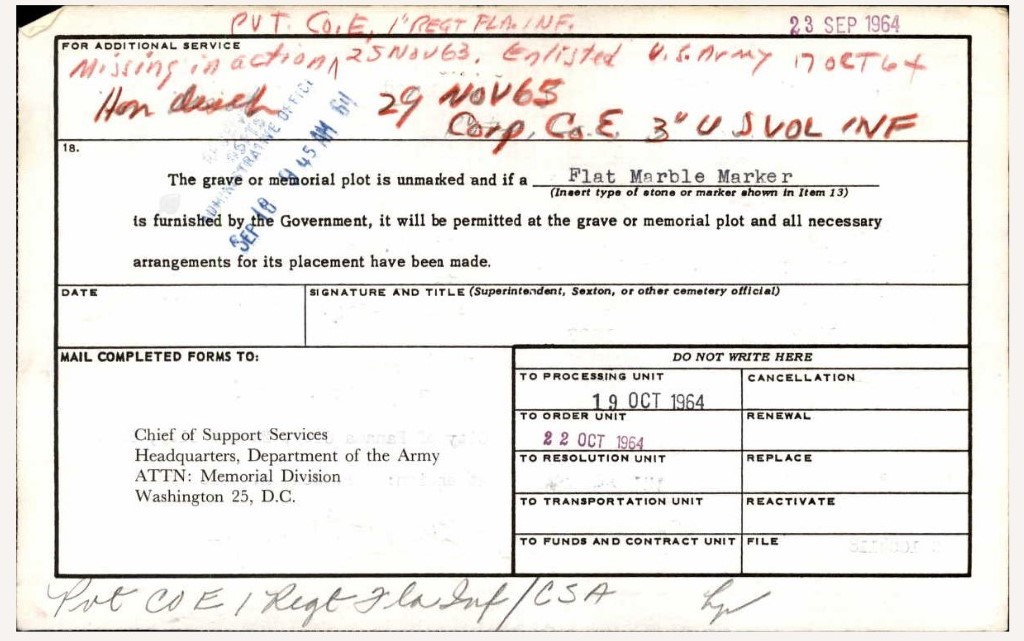


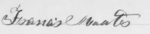

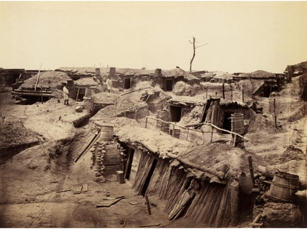
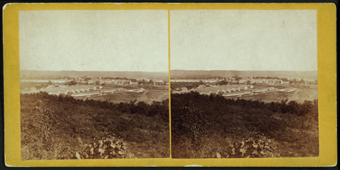
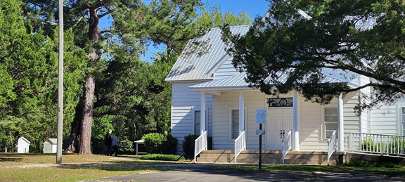


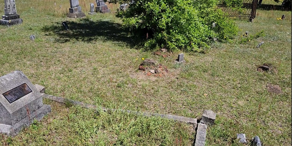
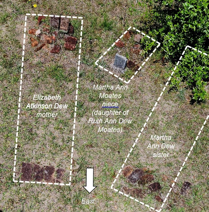

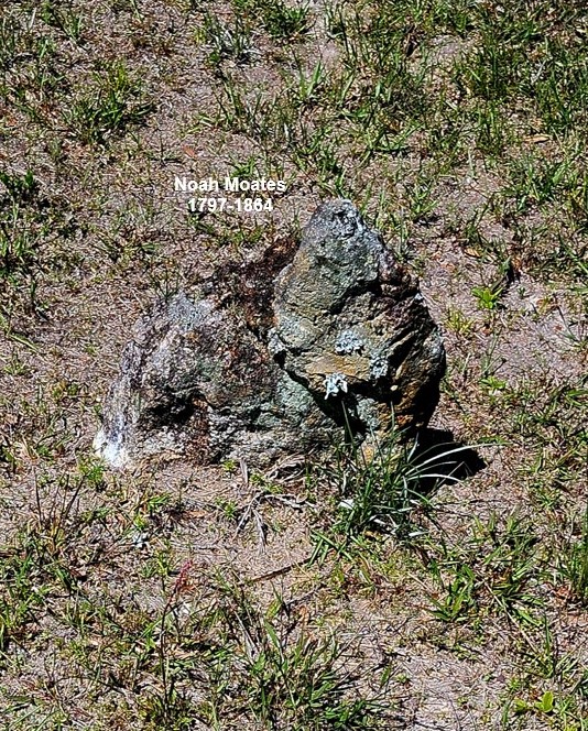


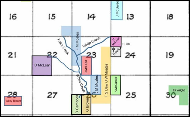


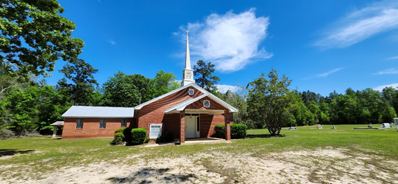


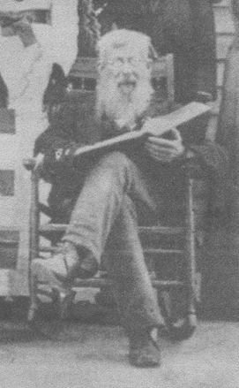
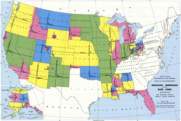


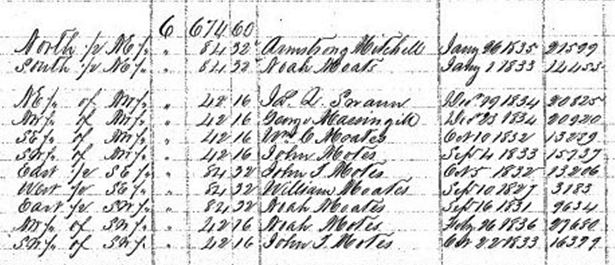


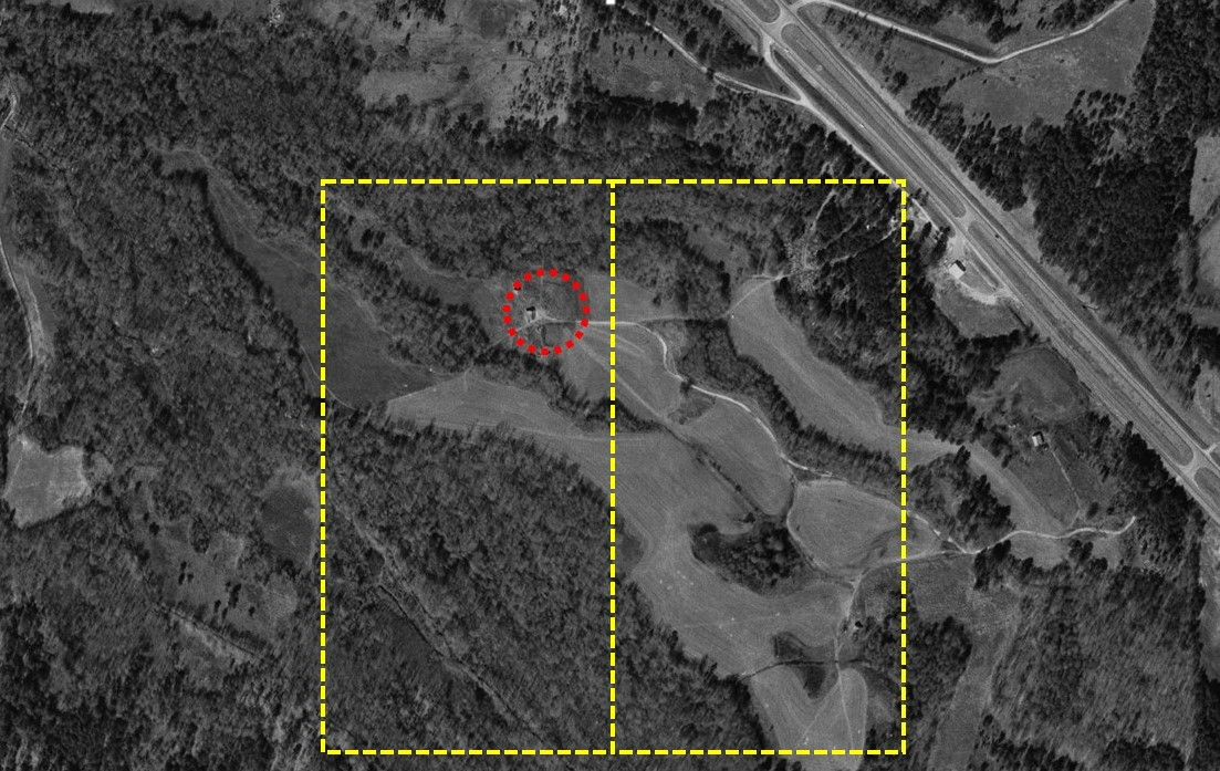


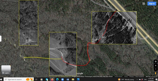

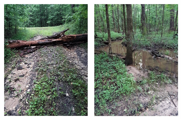


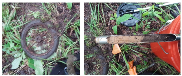


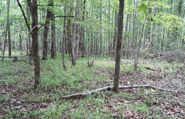
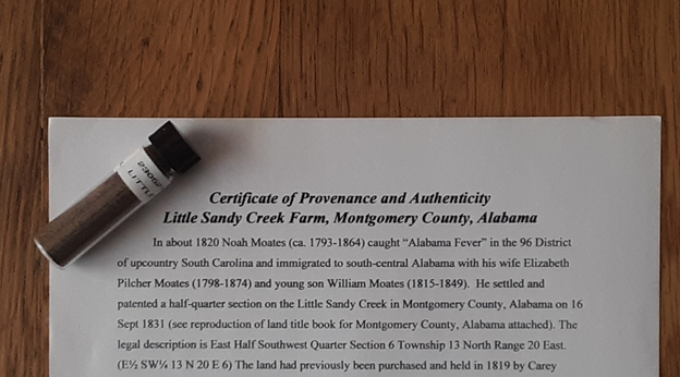


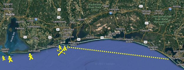


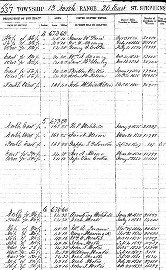
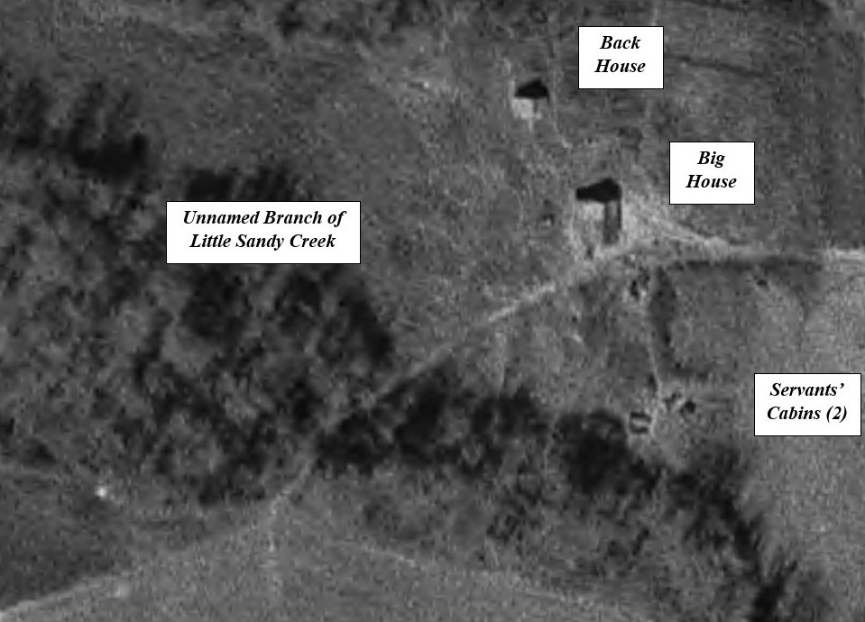


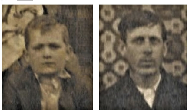
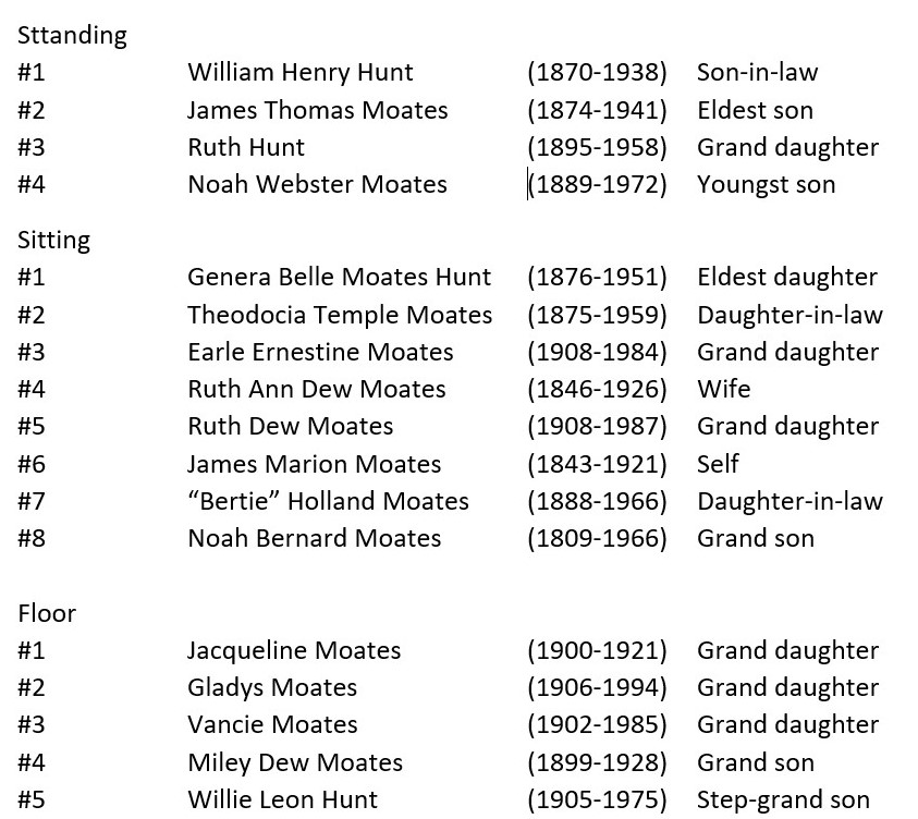


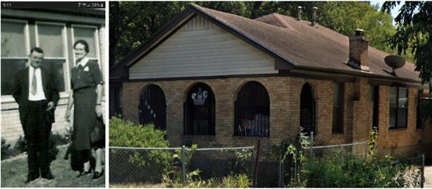

