Feeds:
Posts
Comments

Archive for June, 2023

Hiraeth

In this present age we are a rootless generation. On average, Americans change residence 11.7 times in their lives. [Source: https://www.steinwaymovers.com/industry-insights/ ]  This statistic seems very plausible to me, since in my own childhood my parents relocated six times before I left home, and subsequently, I lived as a nomad myself—moving to sixteen “permanent” residences after founding my own nuclear family—a fact of which I have been reminded by my children, who themselves have itchy feet, as well. So it is not remarkable that I share with many of my contemporaries an inchoate longing for an old home place, a Heimat, lost. Recently, I came across a word for this emotion—hiraeth. This word is a unique gift of the Welsh culture, but is a universal experience, I believe. And having a word for a nebulous sensation somehow seems to give us a handle to grapple with it. I am persuaded that from time to time everybody experiences morriño (Galacian Spanish dialect for a longing for a homeland), or if we were Portuguese we might call it suadade, or even anemoia, the longing for an unknown home or that special homesickness for one’s ancestral home the Germans call Heimatweh.

Where to look for a home?

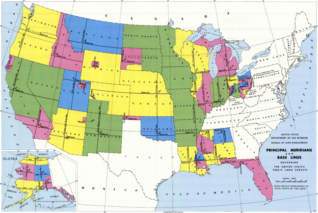
Whatever word we attach to this feeling, my genealogical research has raised the hope of uncovering my patrimonial estate or a homeplace (a Heimat?) that could be the nexus of my hiraeth. But along which branch of the family should I search? I was closest in distance and in affection to my maternal grandparents, Noah Theodore Webster Moates (1889-1972) and Katie Roberta “Bertie” Holland Moates (1888-1966). I learned in studying them that my grandfather was named for his great grandfather Noah Moates (1793-1864). My Pa died never knowing his grandmother’s father. Noah the Elder appears in the records of Montgomery County, Alabama in 1826 as a Justice of the Peace, barely six years after it became a state. His honor was enumerated in the 1830 Census for Montgomery County, Alabama, as well. In the next two decades his name resurfaces in the company of kinsmen who also emigrated from 96 District of South Carolina and were of French Huguenot stock. Noah (1793) as I often identify him, was the grandson of Jonathan Silas Motes, we believe. These family members of unestablished relation who also pioneered Alabama include Carey Motes or Moates, William (or William C) Motes, Elizabeth, Elihu, John, and John T. Motes, Moats, or Moates (a father-son pair we suspect.) Other relatives flooded into south central Alabama at about the same time, notably the brothers Morris and Dendy Motes. The name appears in various forms, as the orthography was unsettled in the 18th and 19th centuries. Historians suggest that the original form was Delamotte or a variant thereof. Nevertheless, in 1833 a clerk entered the purchase of a parcel of land that also appears in a Land Patent that is clearly Noah (1793). We can know precisely where the property was located because of the PLSS, the Public Land Survey System established in the US initially by the Land Ordinance of 1785. [Source: https://en.wikipedia.org/wiki/Land_Ordinance_ooudaef_1785 ]  The key features of this system are the descriptors township, range, and section. Each township is—usually—a square, six miles by six miles in extent with each square mile comprising a section of land. Thus the sections each consist of approximately 640 acres. The PLSS was the brainchild of Thomas Jefferson, who proposed the “Rectangular Land System” that was enacted into law as the Land Ordinance of 1785. [Source: https://mlrs.blm.gov/s/article/PLSS-Information ], barely eight years before Noah (1793) was born.

A Note on Locating Public Lands

In the PLSS, key baselines were defined at various latitudes. In south Alabama the principal baseline aligns with the border with Florida. Thus, the southern edge of township 13N lies 78 (13×6) miles north of the Florida-Alabama line. Likewise, meridians running north–south were also defined, such as the one passing through St. Stephens, Alabama from which ranges were numbered east and west in six mile increments. Thus, range 20E lies 120 miles east of the St. Stephens meridian. Below is a map (courtesy of Wikipedia) of the lands subject to the PLSS.

Map of PLSS (Public Land Survey System) regions with baselines and medians. Source: Wikipedia.com

Detail from previous map showing Alabama-Florida baseline and St. Stephens Meridian.

The public land was offered for sale by the Federal government (after having dispossessed the indigenous peoples who had collectively stewarded it for millennia). The 6×6 mile townships (containing 36 square miles) were subdivided into 36 sections of approximately 1 square mile (or 640 acres), each numbered in a consistent serpentine or boustrophedon (as the ox plows) pattern. Beginning in the northeast corner the sections are numbered consecutively first westward then eastward, alternating directions as shown in the illustration below.  Section 6 is highlighted for special consideration.

Layout of sections in a township that is identified by township number and range number. On the right section 6 that is highlighted in the township map. Quarter SW (Southwest) of section 6, is outlined in black. The eastern half of the quarter section SW is highlighted in blue.

Such holdings were frequently too large an investment for the small farmer, so the sections were subsequently further subdivided into quarters, designated NE (northeast), NW (northwest), SE (southeast) and SW (southwest), each comprising 160 acres. Further subdivision was designed by halving (80 acres) or quartering (40 acres) the quarter section as E½ SW¼ (or ESW) as illustrated in the enlargement. Thus, ESW 13N 20E 6, means eastern half of section 6, township 13 north and range 20 east containing 80 acres. These PLSS designations can be correlated to modern property lines using various on-line resources.

Eighty Acres of “Virgin” Alabama Land

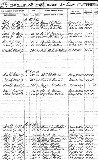
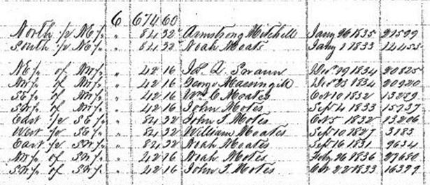
The choice of our example was not arbitrary. Indeed, in the land book from the 19th century we can see the land transactions that included Noah Moates. Notice the entry 3/4 down the page.

The page in original the land book for section 6 Township 13 [north] Range 20 [east] showing the transaction in which Noah Moates purchases the Eastern half of the Southwest quarter.

A close examination of the image reveals that in 1819, at the dawn of the statehood of Alabama one Carey Motes of Abbeville, South Carolina purchased the SW quarter of section 6 Township 13 [N] and Range 20 [E]. Subsequently, Noah Moates purchased the aliquot (a partial section) E½SW¼ of that quarter on 16 September 1831. The price was $1.25 per acre. Thus, he paid $105.40, a sizeable sum in 1831. The land was patented in 1838. A patent functioned as an official deed of ownership.

A later copy confirms that Noah not only purchased the land, but it also reveals his neighbors to the east were his kinsmen William Chesley and John T. Moates (aka Motes or Moats) with neighbors to the north and west to be Messrs. Armstrong Mitchell, Swann, and Massingill.

Land book summary page listing Noah Moates and his neighbors.

We believe that William C. Moates was Noah’s brother while John T. was his uncle, or cousin. Together the South Carolina immigrants formed an enclave, by the late 1830s, having bought up a patchwork of land parcels.

A schematic of the ownership of the aliquots (parcels) surrounding the Moates enclave that was formed by the patchwork of half- and quarter-quarter sections owned by the Moates “boys.”

Below is a twentieth century topographic map of section 6, with the aliquots for Noah (1793) and his brother William Chesley Moates indicated.

A 1971 topographic map with the property lines indicated. The map indicates roads and houses that correspond to those seen in the aerial photographs.
Corresponding aerial photograph in which we can observe the collection of buildings, circled in red.

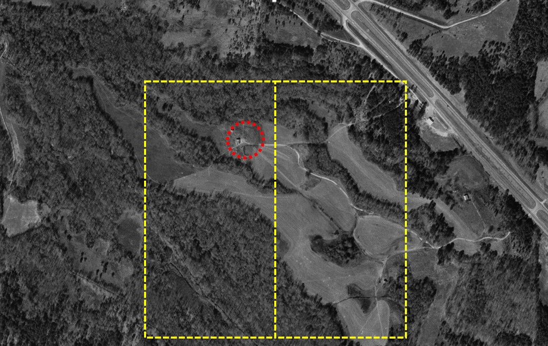
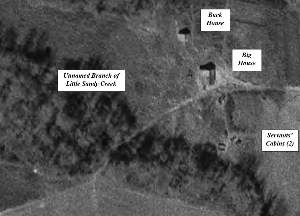
Above is an overlay of the Noah Moates (1831) aliquot and the William C. Motes (1827) aliquot on a 1977 aerial photograph. We can discern houses (circled) and cabins that are made more visible in enlargement (below).

A enlargement of the area where the structures appear on the Little Sandy Creek farm,

The Little Sandy Creek Farm (E ½ SW ¼ Section 6 Township 13 N Range 20 E)

Close examination places the GPS coordinates of the big house at 32.13193, -86.09279. There appears to be a well a few yards west of the Big House.

We can confirm that it is likely that Noah Moates (1793) resided on this land, dubbed the “Little Sandy Creek Farm,” before the census of 1830.  He probably leased or rented the property from his relative Carey Motes in the 1820s. He was residing here in 1830 when the census was made. This we can infer by noting the order and subsequently location of the individuals in the census list. If we plot the location of all of the neighbors who appear in the census in order we see that the census taker meandered from farmhouse to farmhouse. Apparently, the enumerator missed the Noah Moates family on his first pass finding Chesley and John T at home but revisited the Little Sandy Creek Farm successfully a second time. Yellow designates the estimated trek before visiting the Noah Moates family (white circle) and the red arrows the path of the enumerator in successive visits to other farmsteads.

The approximate path taken by the enumerator of the Montgomery County in visiting the farmsteads of the families listed in the 1830 Census.

Noah Moates does not appear by name in any known census before 1830 and in 1840 appears in the census for Pike County while his son James W. Moates appears in Montgomery County, adjacent to his Uncle William C. Moates’ property. By 1850 Noah and family had moved to Eucheeanna, Florida, appearing in the census there. We can conclude that, most likely, Noah Moates owned and/or resided on the Little Sandy Creek farm from before 1823 when daughter Rachel was born in Alabama to about 1849 when they moved south.  Thus, this is the first documented “homeplace” of the Noah Moates clan, although they occupied the site for only about 20 to 25 years before moving on.  Therefore, is this not the “Ole Homeplace” of our family?

The Ole Homeplace Today

But what became of the Ole Homeplace and what remains of the place today?  We can trace the history of the ownership of this tract of land down through the nearly two centuries by searching the property tax books and reading the newspapers for real estate sales. Sometime after 1850 the Little Sandy Creek (LSC) farm was sold to Mr. Martin Willis (1825-1866). We infer this fact from Elizabeth Moates’ (William’s wife’s) appearance as its manager in the 1850 agricultural census in a listing adjacent to William C. In 1866 Mr. Willis died. The property was inventoried in his probate records that also decree that, since the estate was insolvent, much of the real estate holdings were to be sold except for the tract reserved for his widow’s residence that corresponds exactly to the LSC farm. Sarah Ann Ingram Willis (1829-1895), widow and Martin’s heir held the property until her death in 1895. Her son Asa “Acie” James Willis (1860-1946) inherited the estate and sold it in 1899 to Thomas Jefferson Gray (1864-1937). T. J., farmed the property with his nephew William Chappell Gray (1901-1978) until Uncle Tom died. He bequeathed the farm to his nephew, since he had no surviving children. Chappell’s stepdaughter intimated in a private communication that T. J.’s siblings and other relations were upset by this bequest. Nevertheless, Chappell proved his mettle by his hard work for several years to pay off the outstanding debts on the property. Chappell Gray was a colorful character in his own right. He overcame a scandal from a scrape with the law as an alleged bootlegger to become a respected politician and prominent cotton farmer. At his death in 1978 title to the land passed to his second wife Frances Elizabeth Cason Bishop Gray (1912-1996), who subsequently sold the property in 1986 to Mr. H. R. (Robert) Dudley of Dudley Bros. Lumber, the entity that currently owns the acreage and manages it as timberland through a holding company. 

I contacted a member of Mr. Dudley’s family who is a principal in the lumber company and obtained permission to “walk the property.” On Sunday 21 May 2023, my wife and I drove to the logging road entrance off Athey Road, Montgomery County, Alabama and I began my trek back into the past.

A Walk in the Woods

I had for weeks planned my excursion into the woods that surrounded the location of the Little Sandy Creek property. I had mapped our drive in our all-wheel drive Subaru along the logging road that peeked through the trees in the Google satellite views of the area. I carefully overlayed the 1971 aerial images with the corresponding Google images. My plan was to drive to the second clearing, where a white structure appeared to be, and then trek the 150 yards northward to the site of the antique buildings shown in the fifty-year-old aerials. Carolyn, my wife and partner would remain in the vehicle nearby.

A merged image of a Google satellite view and the 1971 aerial photograph.

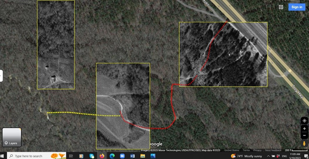
We found the entrance to the property with only minor difficulty, but—how shall I put it?—nothing else went according to plan.

The first obstacle we faced was a locked gate.

Locked gate.

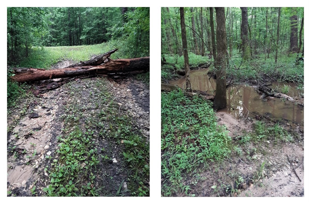
If I had obtained access by borrowing a key, travel by automobile, even a four wheel drive like our Subaru Outback, would have been impossible. In at least three places, fallen timber blocked the track. Moreover, recent rains had filled the many unnamed tributaries of the Little Sandy Creek that traversed the road to produce potential impassable mud holes.

The tract blocked by fallen timber (left). An unnamed tributary in flood posted further obstacles.

Along the way I started a doe. I realized one of the reasons for the locked gate. It was deterrence of unauthorized deer poaching. As further evidence, on the return trek I picked up a buck antler soughed off in a previous season.

I surprised a doe in a meadow. A young bucks antler from a previous season lay at the edge of a clearing. I wondered if some of the deer’s ancestors provided sustenance for my ancestors. I silently thanked the deer for making it possible for my family to thrive in the wilderness.

So leaving my partner in the car at the locked gate your intrepid trekker (me) set off on foot to reach the site that his diligent study of the on-line maps indicated lay nearly a half mile into the woods. I had rehearsed the path in my imagination many times and felt initially confident that I could easily (and rapidly) navigate to the spot using my GPS-enabled Google Map. I did not count on the disorienting nature of the deep, unfamiliar woods or the change in the landscape since the last aerial photograph. Still I could draw on my dead-reckoning skills acquired as a youth traipsing barefoot about the swamps of my coastal Alabama childhood home. All began well as I followed the logging road, as I had envisioned from my armchair weeks earlier. I made it without incident to the first clearing, probably the site of the William Chesley Motes’ home two hundred years earlier. Nothing remained there except the grass-covered meadow. It was there that I took what turned out to be a wrong turn. I was led astray by an official-looking sign bearing a number 1 and an arrow.  The sky was overcast so I could not readily discern the direction by shadows.  The old bush wisdom of moss-on-tree-trunks-indicating-north was of no use since moss grew in abundance on all sides of the oak trees. Furthermore, my phone did not have a compass app installed.

Moss grew on all sides of the tree trunks. I lost my sense of direction for a time.

I had promised Carolyn that I would check in frequently using our walkie-talkies that we had purchased for the occasion. It worked once when we tested it but I could not reach her subsequently, either because of technical difficulties or operator error. Minutes passed as I stumbled through the forest heading south (instead of west). At last, I reached what the number 1 alluded to: a plowed field.  The field still appeared as a landmark on my satellite map. I realized that I had wandered farther afield in the wrong direction so I turned northward to hike and intercept the logging trail again.  At that moment I recalled the sad stories my research had brought to light of the people who became victims of this very swamp. In September 1974 eighty-year-old Leatha Wilson was found dead not far from where I stood. Newspaper accounts of the event also alluded to the disappearance of five-year-old Willie Williams, who in 1969 ran into the swamp with his dog. His dog returned. He did not. He was never found. I suppressed the panic that began to arise that the victims must have felt. I focused on the map and the little blue dot that represented my position and verified that I was now moving toward my goal. I also heard the sound of traffic on the Troy Highway to my right. I also tried to keep an eye out for snakes and other dangers. But I overlooked, concealed in the under growth, a fallen log that caught my toe. I fell face first into the leaf litter. As I lay on the soft ground, just then my phone chimed a notification of an incoming text. Carolyn was worried. I replied with a cramped hand as I lay in the dirt, “Will tAlk soob” [sic].  Awkward is too kind of a description of my state.

My meanderings led me to a tilled field. Not my intended destination.
The swamp had claimed two victims in 1969 and 1974. I wondered briefly if it would take another in 2023.

Rising from my humbled position, I consulted the map. (See left below) It suggested that I return to the highway and drive to a different place and walk in again.  I chose to bushwhack through the woods to the logging trail and thence on to my destination. I realized that the dark patches in the satellite were fens, natural swampy ponds that were persistent landmarks. Thus skirting the muck, I managed to return to the logging trail and ultimately to the second clearing that I had determined lay just south of the homeplace I had seen in the 1971 aerial photograph. When I arrived at the clearing, the little white building I was expecting was gone. Only four concrete footings remained of what I had surmised was a storage shed.  I was filled with renewed hope, however at the “ground truth” that my goal was within reach. I identified the path I had seen on the satellite view and proceeded up the path about 300 feet counting out the paces, left-foot-right-foot, 5 feet, left-foot-right-foot, 10 feet. Then I turned right and trekked about 100 feet into the woods. Surveying the understory, I caught sight of debris. Twentieth-century trash lay scattered about. Derelict appliances were strewn among the oaks and pines: a top loading washing machine, a bronze-colored refrigerator, a toppled gas range. Surveying wider I encountered the remains of a well that survived the demolition of the houses. It was a large diameter concrete culvert set vertically in the ground. I glimpsed the surface of muddy water about three feet below the surrounding forest floor.  The GPS coordinates corresponded to those that I had concluded were those locating the well, as shown in the aerial photograph.  This was indeed the place I had identified.

I had the benefit of a navigation app on my phone. I knew were I was but initially did not know which direction to go. This contributed in part to my unintended side trip.

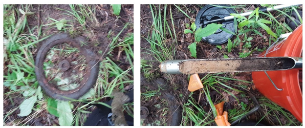
I brought out my trusty metal detector in hope of finding buried evidence of antique nails, a way to date a structure.  In a few seconds of sweeping the area it sounded an encouraging “beep, beep!”  I dug eagerly with growing anticipation. What came to light a few inches beneath the surface is shown in the photo below (left). The object that I uncovered was a tricycle wheel with a rubber tire through which a large tree root had insinuated itself. The find discouraged further metal detecting. My calculation was that there would be too many “modern” objects that would mask any earlier objects. A thorough scan would consume all the time I had remaining in fruitless searching.  Nevertheless, I wanted to document what I had found as best I could. I retrieved my soil corer and extracted a sample (right). It revealed a black topsoil layer of about 4 inches (10 cm) deep overlying an abrupt transition to sand. This finding suggested that since the homeplace was abandoned in the late twentieth century, the composted leaf litter has built up at about 5 mm per year or more. In 200 years any artifact might be buried as deep as a meter (40 inches).  I was not prepared for an archeological dig. From the soil core I concluded that before the demolition of the house in the late twentieth century the soil was probably barren packed sand. Later, as I reflected, I realized that the find, a child’s toy, was evidence that the house that had stood on this spot had been home to a family, perhaps a tenant, in the era when the property was owned by Chappell Gray. Perhaps the child, who rode what is now a relic of at least a half century vintage, was known to Leatha Wilson and might have been a playmate of Willie Williams, as well.

I, at last, found the site of the house shown in the 1971 image.
My metal detector find, a child’s trike wheel. (left) I used corer to sample the subsurface soil stratigraphy. It revealed a four inch layer of loam overlying packed sand.

A low mound caught my eye. I moved closer and observed that it was a pile of rubble. “The remains of the chimney,” I thought. Indeed, the pile was substantial: about three foot high and eight to ten foot in diameter. I extracted representative samples from the debris pile.  I thought to myself, “These will be helpful in establishing when this house was built.”

Rubble pile of chimney bricks. Insert: specimen selected for dating and analysis.

Later I documented the bricks with detailed photographs that I shared with various experts in the field of brick making and masonry. Below is a montage of a representative half brick. Close examination reveals ten V-grooves running the length of the brick as well as telltale longitudinal scratches, except at the ends where I noticed vertical striations that suggested the clay had been end cut.

The Tale of a Brick

Representative brick collected from ruins at site of Little Sandy Creek homeplace. Expert opinion (Don Adkins of Old South Brick) suggests this is a stiff-mud extruded end cut brick. The process was introduced in the US in late 1870s and became common in Alabama after 1895 or later. These bricks perhaps were manufactured by Jenkins Brick of Wetumpka, Alabama.

Later that same day, when we visited the Pioneer Museum of Alabama in Troy, we observed similar bricks appearing in a reconstructed tenant house on the grounds of the museum.  We ultimately ascertained that the original structure(s) stood on the Segars Plantation in Troy. Hugh Richmond Segars was granted a patent for the farm in 1851. Thus, we concluded that the bricks, if indeed they came from the Segars Place, must date from after the mid-1850s.

Reconstructed tenant house from Segars Plantation, Troy, Alabama located currently at the Pioneer Museum of Alabama, uses brick that are very similar to those I recovered from the homeplace site. Hugh Richmond Segars (1822-1884) patented land in 1851 for his plantation from whence the original structure(s) were salvaged. In 1860 he had 10 enslaved servants housed in two houses on the estate. The museum exhibit was reconstructed from the ruins of these two houses. Therefore, the bricks probably date after the founding of the farm in about 1850.   Note that the bricks markedly resemble those found on the Little Sandy Creek Farm.

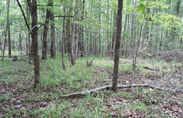
As I was composing this post, I had an illuminating discussion with Mr. Don Adkins of Old South Brick and Supply, Jackson, Mississippi, a vendor of vintage and antique brick. From the photographs and description that I had sent him he was able to determine that the bricks were fabricated by the stiff-mud-extrusion-end-cut process that was employed by Jenkins Brick Company of Wetumpka and later Montgomery, Alabama, beginning in the late 1890s. He opined that the bricks could not be any older than 1895 because the extrusion process was only patented in 1863 and took decades to gain currency.  In 1899 the Jenkins Brick Company that used the method of brick making was incorporated in Wetumpka, Alabama, north of Montgomery. Bricks from earlier periods would have been hand molded and probably would not have survived the damp of the swamp, since they were low-temperature fired and lacked much vitrification.   He further remarked that the age of the bricks did not negate the possibility that the house had been built earlier, since it was common practice to tear down failing chimneys and rebuild them with newer brick. Thus, all we can say is that very little remains of the original homeplace except for the land. The cleared space where the late 19th century structures stood is in the process of returning to its pre-habitation condition. Studying the photograph of the site below, we see smaller diameter hardwoods estimated to be less than 50 years in maturity. The 1820-vintage buildings of the Noah Moates family have vanished, victims of the ravages of Nature and of subsequent “improvements” by succeeding occupants of the land.

A view of the previously clear area that is or is near the site of the original Alabama ancestral homeplace of the Noah Moates family that we call the Little Sandy Creek Farm. Nothing apparently remains of the 1820-1850 homestead except the land.

My children expressed their concern that I would be disappointed by what I found in my search to satisfy my hiraeth. I assured them that I did not know what to expect, so anything would be acceptable. What I found was a sense of the presence of my ancestors. The land originally was verdant and provided them with timber to build a log home, probably like examples of the two-room “Dog Trot” style common in central Alabama at the time. It was here that my great-great grandmother Rachel Moates, the mother of James Marion Moates (aka Miley), was born in 1823.

I concluded, also, that the land never really belongs to us. Not the earth, not the water, not the sky above. At best we borrow it from Nature. Indeed we belong to the land, the place of our nativity. It gets in at the root and works itself out in us and our children up the trunk of our family tree and out to the branches and needles or leaves as it does with the loblolly pine and water oaks.

Succeeding generations of men will—in the name of progress—obliterate every trace of our habitation. Likewise, Nature will reclaim her proprietorship if we do not continually maintain and restore the place. I am reminded of the dialog of the film Out of Africa in which Karen Blixen complains to Denys Hatton, her lover:

Karen: “Every time I turn my back it wants to go wild again.”

Denys: “It will go wild.”

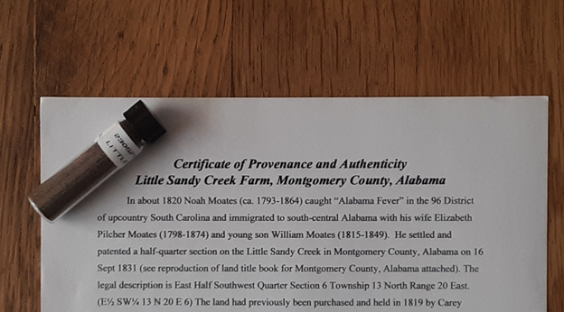
In truth, the locale of my Alabama homeplace, my Heimat, has gone wild. All that remains is the earth upon which they walked. Thus, I can think of no more appropriate talisman of my family’s presence in this space than a souvenir sample of the soil they trod centuries before. With the help of my grandson Elijah Matteson, age six, 5x great grandson of Noah Moates, I prepared 2 dram (about 7 cc) labelled samples of soil that I had collected at the site, accompanied by a certificate of provenance and authenticity. Below is a photograph of one such sample with the certificate. They lie upon an antique depression-era table, factory built over a century ago, and refinished for my mother Audrey Moates Matteson (1926-1998) by my grandfather Noah Theodore Webster Moates (1889-1972) over a half a century ago during my memorable summer with my beloved grands.  It is the people that make a place live in our memory. It is this longing for knowing them and touching them where our hiraeth becomes palpable. In knowing the place where our roots lie, we know ourselves a little better. Being there was worth the effort to get there.

Read Full Post »

The Gulf of Mexico as viewed from Ft. Walton Beach, Florida in May 2023. The beauty and calm of the sea belie its danger and hunger for souls.

Every once in a while, when researching family genealogy and personal history, I come across an incident that is so compelling that it breaks my heart. When this happens the history of my ancestors and of their struggles coalesce in my consciousness and their story demands telling. Such is the case in the family of Francis Marion and Mary Peel Moates, my great grandfather’s uncle and aunt. The tragedy they experienced centered on the sinking of the Sloop Amelia.

The Family of Francis Marion Moates and Mary Rebecca Peel

I first met Francis in my inquiries when he appeared as a young man, the uncle of my great grandfather James Marion Moates; since he was only six years older than Francis M. he was more like an elder brother than uncle. For him James Marion Moates was named, in part. Uncle Frank (as I shall call him) was born in land-locked Pike County, Alabama probably near Briar Hill and probably in the very house where Grandpa Jim first opened his eyes six years later.) Frank and Jim served together in the same unit of the Florida Infantry (CSA) during the Civil War. At Chattanooga, however, their paths separated: Frank was captured at the Battle of Missionary Ridge, while Jim was injured but eluded the Blue Coats.


Frank had married Mary Rebecca Peel in Euchee Anna, Florida in 1859 before enlisting. Together they had ten children by 1886 when Mary ended her child bearing years at age 44.

The F. M/ Moates family made their home in northwest Florida, first near present day DeFuniak Springs where Noah Moates had settled in 1850, then near other family in Orange Hill, Washington County just down the road from Jim and his growing family. But ultimately—as we learn from Mary’s obituary (Panama City Pilot 15 Nov 1928 p 6)—in February 1879 the couple and their seven children, who had been born by then, moved to the shores of St. Andrews Bay near present day Panama City, Florida. They purchased a half section and built what is reported to be the first sawmill in the county following the war. Below is a montage of present day West Bay with its million-dollar lots and an 1888 map showing the Moates Mill in Section 35 Township 3S Range 15W. The red highlighted lot on the left marks the approximate location of the mill today where no trace of the historic structure remains, erased by progress.

Location of Moates’ sawmill on shore of St. Andrews Bay, Florida in 1890 (right) and 2023 (left)

It is no wonder that after a decade of living beside the Gulf, two of the Moates girls married mariners. The eldest daughter Mary Francis Moates (born 1863 in Eucheeanna) married William Stephens, a commercial fisherman, while Elizabeth Carrie Moates (born in 1874, five years before the move to St. Andrews) married a Greek immigrant, John Constantine. Captain John piloted a freighting sloop, the Amelia back and forth across the Gulf of Mexico visiting ports from New Orleans to Tampa.

A Fateful Excursion

So it was that one Sunday, 29 March 1897, a party of nine souls embarked from St. Andrews Bay bound for Pensacola, about hundred and thirty nautical miles away. On board where Captain John Constantine, his wife Carrie Moates Constantine, their three young children (sons Nicky age 3, Tony C age 6 months, and an as-yet-unidentified child), Mary Moates Stephens and her daughter “Nettie” about sixteen, the Moates sisters’ brother Ben Moates (25), and a young Greek man variously identified as “Moses” or “Christopher Samiota” (probably actually Samiotes). The newspaper reports are a bit sketchy about the relationship of the young Greek to the party: some dismiss him as only a deck hand, others allude to him as Miss Stephens’ fiancé.  In any case, the passengers were intent on visiting relatives in Pensacola and obtaining a trousseau for Nettie’s upcoming wedding according to newspaper accounts. Captain Constantine had more commercial interests in mind, however, as he had on-loaded a large number of casks of oysters for delivery to the dock in Pensacola.  The merchant sailing vessel sat low in the water, burdened with the heavy load below deck.

A Typical Merchant Sloop

No drawing or detailed description of the sloop survives except for the title and the capacity of “six to seven tons.” As an aid to our creative imagination we provide the images below of such sloops that often were single masted but occasionally sported twin masts and ranged from 30 to 40 foot in length with sails fore and aft.  Several prior mentions of a Sloop Amelia appear in the shipping news. One interesting account tells of a lightning strike in New Orleans that did extensive damage a few years earlier. Perhaps the more superstitious might have taken such an event as an evil omen, but on this occasion the happy group were oblivious to such dark clouds of superstition as well as the real storm brewing over the horizon of the Gulf waters.

The 19th century sloop Welcome (left), a model of a typical sloop that plied the waters of the Gulf (center), and a twentieth century reconstruction of a sloop (right).

The Tragedy

Ben Moates was found, washed up on shore in Pensacola, half dead. He had clung to a hatch to stay afloat through the raging gale. He told, as he recovered, of hours of the captain and crew fighting the storm and struggling to keep the ship afloat only, at last, to be capsized and flooded when the hatches were ripped from the holds. He had tried to save a woman (presumably his sister) and her child, but failed when they were torn from his grasp and drifted away to their death. In all, eight souls perished, claimed by the implacable fury. He, like a real-life Ishmael, alone survived to tell the tale.  I have wondered if Ben spoke much of his harrowing misadventure in the remaining 56 years of his life. He left no known children to tell us, since his only child with wife Nora Thompson Moates died at birth. I suspect that he may have been troubled with survivor’s guilt, but we cannot know. Nevertheless, the event did not put him off venturing out to sea again apparently for he continued his career as a fisherman.

Benjamin Franklin Moates (1872-1953), sole survivor of the Sloop Amelia

The Aftermath

Grief like the waves on the white beaches of northwest Florida came in pulses in the weeks following the tragedy. Bodies were discovered from time to time for the next several weeks on the beaches from Pensacola to Dauphin Island near Mobile where I was born 50 years later. The first found were the corpses of two of the Constantine boys Nicky and Tony, one on each shore of the entrance to the harbor at Pensacola along with the stern board bearing the ship name Amelia. In the coming weeks, Mr. William Stevens diligently searched for his wife and daughter. He responded to each announcement of a body encountered, often with great disappointment. Ultimately, he apparently did recover the remains of his drowned wife Mary Francis and daughter Lettie. The only other body, greatly decomposed, to come ashore was identified by jewelry to be those of Carrie Moates Constantine.  The other three individuals were never see again: Captain John Constantine, Christopher Samiotes, and the unidentified child of Carrie and John Constantine.

Map of coast of Gulf of Mexico coast from St. Andrews/Panama City (right) and Pensacola (left) The figures indicate the approximate location where bodies were found, washed ashore. The X indicates the approximate spot of the accident.

The bodies that the sea gave back were interred in St Andrews and their names were engraved in stone on their headstones. They faded from memory anyway as those who knew and loved them passed, themselves. First to succumb was Francis Marion Moates, who was already an invalid in 1895 (possibly as a result of his imprisonment during the Civil War), Alternatively, he may have been overcome by the tragedy of losing two of his beloved daughters and four of his grandchildren in a single blow.  He died about six months after the accident, as noted in his death notice in the local paper.

His death left Mary a widow, at age 55, caring still for three minor children at home. Mary Peel Moates had already been through much in her life. As a new mother of two in 1864 she endured the raid on her hometown of Eucheeanna when Union General Ashtoth’s troops occupied and stripped the countryside of food and horses, liberating the enslaved people and leaving her destitute. And she endured with apparent equanimity the latest blow to her family just two days before the 38th anniversary of her marriage to Francis Marion. Not content to play the victim, Mary applied for a widow’s pension on 7 Nov 1897 very soon (if not days before) Francis’ death. With the help of her grown sons she provided for the family, Three years later, in the 1900 Census she is enumerated as “Head” with her sons, including Ben, listed as “fishermen.”  Twenty-three years later we find grandmother Mary Moates residing with the family of her youngest daughter Annie Moates Porter. In 1928, Mary Rebecca Peel Moates died in St. Andrews, Florida, surrounded by family at the ripe age of 86.

The Take Away

As I contemplated this tragedy I was reminded of Psalm 107.

And the words of Job seem apropos as well to the stoic character that Mary seemed to exhibit.

Yet, I am astonished at the way the knowledge of the great tragedy has affected me 126 years after the fact. I was particularly struck by their loss as I gazed out on the Gulf of Mexico while vacationing with my wife and son’s family in Ft. Walton Beach, Florida, on Okaloosa Island halfway between St. Andrews and Pensacola. Perhaps the lesson we should take away from this story is this: life is precious and brief. We sail upon its surface with no guarantees of success. I here renew my resolve not to take a clear day and a fair wind as my right or as a given but, rather, as a gift, a grace. May we not squander our time here in meaninglessness and pettiness, and thus the memory of those who were lost that March Sunday will continue to be a blessing to us today.

Read Full Post »

In 1793 Noah Moates, I believe, was born to William Chesley Moates Sr. (1760-1830) and Rachel Adams Moates (1763-1830), descendants of Huguenot immigrants from France who were residing in the 96 District (after 1800 Abbeville County) of upcountry South Carolina. Responding to the urges of “Alabama Fever,” Noah at about the age of 27, along with his young bride Elizabeth Pilcher Moates (1796-1874) and infant son William (1815-1849), began his westward journey on the Fall Line Road across Georgia to the Federal Road to Macon and Columbus, Georgia and on to Montgomery County, Alabama. The first direct evidence of Noah’s presence in Alabama appears as a record of his appointment as Justice of the Peace for Montgomery County in 1825.  Indirect evidence comes from the later census-documented 1823 birth year of daughter Rachel (1823-1872) that is universally reported to have occurred in Alabama. She was the mother of my mother’s grandfather, James Marion Moates (1843-1921) by an illicit affair with William Goodman Miley of Pike County, Alabama.

Noah settled on and later patented a half-quarter section near Little Sandy Creek in Montgomery County, Alabama on 16 Sept 1831. The legal description of this aliquot is East Half Southwest Quarter Section 6 Township 13 North Range 20 East. (Abbreviated E½ SW¼ 13 N 20 E 6). The land had previously been purchased and held in 1819 by a Carey Motes of Abbeville, S.C. (Carey may have been a kinsman of Noah, but the relationship is unclear)  Nevertheless, apparently Noah Moates rented and resided on the land until he purchased it. The ownership of the tract subsequently (after about 1853) transferred from Noah Moates to Martin Willis (1825-1866), and—on his death—to his heirs: wife Sarah Ann Ingram Willis (1829-1895) and son Asa “Acie” James Willis (1860-1946). The latter held the property until he sold it in 1899 to Thomas Jefferson Gray (1864-1937), upon whose death the tract passed to William Chappell Gray (1901-1978). The bequest by T. J. Gray, who had no living children, to his nephew Chappell angered Chappell’s relations according to W. C. Gray’s step daughter but the diligence of the younger Mr. Gray in paying off the debt on the property assuaged any doubt of his intent and resolve.  Indeed, Chappel held the property to the end of his days. Chappell Gray was a colorful character in his own right, one who overcame legal troubles for bootlegging in the 1920s to become a long-time county commissioner and widely respected and successful cotton planter. Following his death, the estate of W. Chappell Gray sold the property to H. R. (Robert) Dudley of Dudley Bros. Lumber in 1987, the current owners. Interestingly, a farmhouse survived on the property at least until 1971 as shown in the aerial photograph below. It was located at 32.13193° N, 86.09279° W. 

Reproduction of Montgomery County Land Book. Note that Noah Moates appears among the owners of section 6 in the lower part of the page.
Aerial photograph (1971) of Chappell Gray property (owned 1831-1853 by Noah Moates) showing structures and well, now demolished and covered in forest. The big house was located at 32.13193° N, 86.09279° W.

The Little Sandy Creek Farm, Montgomery County, Alabama

On 21 May 2023, I, the author Samuel Matteson (with permission of the owners), visited the site of the former structures. Evidence of the demolished buildings remained. I believe that near this spot all of the children of Noah Moates were born [except for William and the possible exception of Francis Marion Moates (1837-1897)]. This assertion includes, notably, Rachel Moates (1823-1874), mother of James Marion Moates and great-great grandmother of the author. A rubble pile of chimney bricks and a debris field is all that remain.  Twentieth-century trash such as abandoned kitchen appliances are sad evidence of the buildings that once graced the farm.

Photographs made by the author on his visit to the site on 21 May 2023 that document the current conditions of the farmstead.  All that remains of the buildings that appear in the 1971 aerial are household debris and rubble, as attested by this pile of chimney bricks. shown in the lower image

A Move to Briar Hill, Pike County, Alabama

In 1836 hostilities broke out between a bellicose faction of the Creek Indian Nation and Euro-American colonizers.  This threat may have been in the mind of Noah Moates, in about 1835, when he moved from his farm in Montgomery County (the Little Sandy Creek Farm) to occupy a leased acreage about 15 miles farther south in Pike County.

While it is hard to know for sure Noah’s motivations, the locus of the conflict later called the “Second Indian War” was indeed near the Alabama-Georgia border east of Montgomery city, not far away. We can establish that about that time Noah moved to an as-yet-unidentified location near Briar Hill (Township 11N Range 19E). It was probably here that Francis Marion Moates was born in 1837 and where, six years later, James Marion Moates (named in part for his toddler uncle) first saw the Alabama sunlight on 3 Nov 1843. As we asserted earlier, James Marion “Miley” Moates was the offspring of an illicit affair between his mother Rachel Moates (1823-1874) and a married man, Deacon William Goodman Miley, co-founder of the Pisgah Primitive Baptist Church just a few miles from the farm on which the Moates family likely resided from about 1835 to about 1849. (Elsewhere in earlier posts in this blog under the general title “Tell Me Thy Name” I have detailed how we have come to this conclusion. The interested reader is refered to that discussion. Our purpose here is a chronicle of Father Noah Moates.) In the aftermath of the presumed scandal surrounding James’ birth, both the Moates family and the Miley family decamped from the community.  The Mileys headed to Tampa, Hillsborough County, Florida. At about the same time In 1850 Noah Moates and family appear in the census for Eucheeanna, Walton County, Florida.  Meanwhile, Rachel and James were living under the name “Miley” nearby in Walton County. Interestingly, an 1849 advertisement claimed “Valuable Land” offered in Eucheeanna with generous terms: quarter down and one quarter annually for the remaining three years. Thus, if Noah Moates bid on the property in December 1849 and made the down payment in early 1850 for a tract in Eucheeanna, he would have finished payment in 1853, as he is recorded doing. The patent was awarded four years later for several acres near the confluence of Folks Creek and White Creek about one mile west of the Euchee Valley Presbyterian Church. The advertisement shown may be the one Noah Moates actually saw and to which he responded.  

A New Home in the Euchee Valley on the Banks of White Creek

The legal description of the likely boyhood home of James Marion Moates in Eucheeanna, Walton County, Florida is Northwest ¼ of Southwest ¼ Section 6 Township 13 North Range 20 East (NWSW 13N 20E 6). The “ole swimmin’ hole,” as the current owner referenced the confluence of Folks Creek and White Creek, is located on the property and is shown in the photograph. The location is familiar to the current owner Mr. James Armstrong (age 84), who swam there as a youth and also was probably a very familiar sight to James Marion a century and a half earlier. The property remained home to the Moates family for decades, even after Noah expired near the end of the Civil War. Those in residence at the farmhouse on 24 Sep 1864 saw a Union detachment invade the town and “requisition” all livestock and provisions in the area. The winter months that followed must have been lean times for them, indeed. Moreover, I conjecture that the mortal remains of several family members are buried somewhere on the property in unmarked graves, albeit a fact that is as yet unconfirmed.  In happier times it was here in February 1866 that my great grandfather James Marion Moates married Ruth Ann Dew, daughter of the Preacher Thomas Spenser Dew.

Thus, a life—that began in South Carolina—ended in the community of Eucheeanna, Walton County, Florida. Along the way he and Elizabeth sired a family of three daughters and three sons: Rachel Moates, Martha Jane Moates Teal Lassiter, Sarah Elizabeth Moates Hutto, William Moates, James W. Moates, and Francis Marion Moates.

What Motivated Noah’s Odyssey?

The question naturally arises: “What motivated the odyssey of Noah Moates?” “Alabama Fever” was rampant in the Carolinas in the 1820s. Apparently, it was particularly epidemic in the Moates family, since several of Noah’s family members moved to the region at the same time, notably his immediate neighbors William Chesley Moates Jr. (brother) and John T. Moates (uncle or cousin), and Morris Motes (cousin) and Morris’ brothers.  Noah’s brother Jonathan Moates also accompanied his elder brother on the journey and interacted frequently over the decades, sometimes even as a member of Noah’s household.

Land!” was the source of the infection, indeed. Verdant, virgin, affordable soil was to be had in the areas recently offered by the government that it had wrenched from the control of the newly dispossessed indigenous inhabitants. But after about fifteen years of cultivation in the manner of the early 19th century agriculture the sandy soil of Noah’s Montgomery County farm probably became exhausted and crop yields declined. It would be nearly a century before scientific methods of agriculture would be pioneered by—ironically a black man, Booker T. Washington—and show the way to sustainable yields. Moreover, the years of 1830-40 saw heavy rains and poor crops in Alabama. The Little Sandy Creek property is still prone to flooding and is often described as a “swamp.”  In fact, in the 20th century at least two individuals perished after becoming mired in the trackless swamp of the Little Sandy Creek woods. Thus, while he still retained ownership of the Montgomery County property (son James Moates is listed as head of household in Montgomery County in 1840), Noah also leased a farm near Briar Hill, as documented in the 1840 Census for Pike County. It was here that Rachel Moates, his eldest unwed daughter, was “found with child.”  Five-to-six years after James Marion Miley Moates was born, Noah moved his family to the thriving community of Eucheeanna in Walton County, Florida. Perhaps a little bastard “Miley” running about the community was too great a shame to endure. In any case, sometime soon after 1850 Noah Moates sold the Montgomery County property to Martin Willis and reinvested the proceeds in over 200 acres in the Euchee Valley. In Florida the family grew and endured, spreading in the following decades throughout northwest Florida and southeast Alabama. Noah died sometime about 1864, followed a few years later by his widow Elizabeth after 1870, who had lived in the Argyle home of their son James W. Moates in her final days.

After Mr. Miley died, although she was under no legal obligation to remain unwed during his lifetime, Rachel Moates “Miley” married a Mr. Gleason of Eucheeanna. He was probably the elderly, blind father of Phillip Gleason who appears in the 1860 Census. In the 1870 census we find Rachel Gleason residing with her son James and his wife Ruth Ann Dew Moates in Eucheeanna, soon after their first infant Mary Ann Moates had died. In the succeeding years she vanishes from the historical record, presumably laid to rest on the family farm of her father..

The Meaning of Land to a Southerner

            Land was always the attraction and the goal of our pioneer ancestors. It meant status as well as survival. Indeed, the earth was ever the source of their sustenance as farmers and was inevitably the ultimate destination of their bodies as mortals.

Read Full Post »